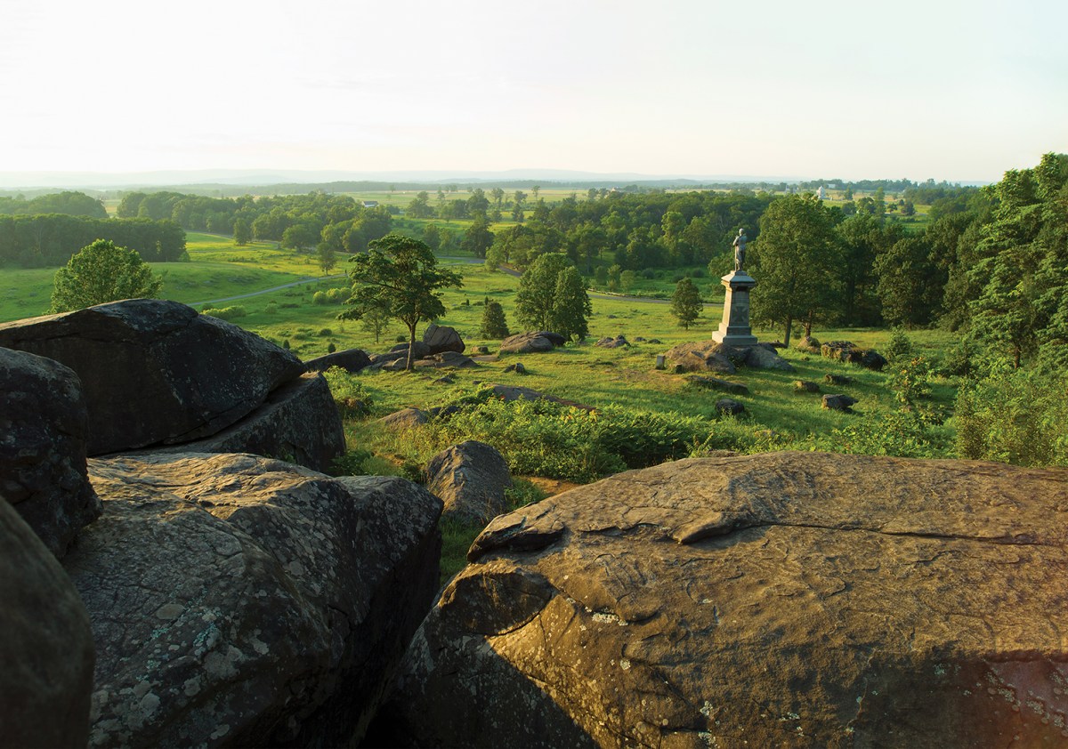
Little Round Top, at Gettysburg National Military Park, Pa., offers a sweeping view. From this hill, on the left end of the Union line, Lt. Col. Joshua Chamberlain led the 20th Maine Volunteers in a bayonet counterattack against the 15th Alabama Infantry and other Confederate units on July 2, 1863. (Tetra Images (Getty Images))
Share This Article
Battlefields are where history happened—for better or for worse. As Winston Churchill once observed, “Battles are the punctuation marks in history.” Battles, however, are very complex events. You can read many books and look at countless maps and still not have the gut-level understanding of what really happened and why it happened that way. Thus, the classic military adage, “See the ground.” That’s sage advice whether you are planning to fight a battle or trying to understand it long after the fact. No two battles are the same—even battles fought on the same piece of ground at different points in history. The compositions of the opposing forces, the contemporary weapons technologies, the tactics of the period, and the weather the day the battle was fought are never the same. The ground, however, changes very little, and the terrain can often be the dominating factor in the battle. Broken and compartmentalized ground usually favors the defender, wide-open terrain habitually favors the attacker, and gravity always confers an advantage on the side that holds the high ground. Very little in the brave new world of cyber operations will help a military force conduct an opposed river crossing. Kinetic energy still counts. No two historical battlefields are alike. Some have been almost completely built over, while others have changed relatively little since the swords were sheathed or the guns fell silent. Fortunately, there are many excellent battlefields that are historically significant, comprehensible, visitor friendly and (mostly) easy to reach. On the following pages are photos of Military History’s top recommended sites for any battlefield enthusiast’s bucket list.
Beautifully preserved Fort Ticonderoga, near the south end of upstate New York’s Lake Champlain, was the site of several battles in 1758–59, during the French and Indian War, and in 1775–77, during the American Revolutionary War.
(Roy Johnson (Alamy Stock Photo))This Martello tower was erected on Quebec’s Plains of Abraham a half century after British forces under Maj. Gen. James Wolfe climbed bluffs like those visible on the far side of the St. Lawrence River to defeat the French under Lt. Gen. Louis-Joseph de Montcalm on Sept. 13, 1759, amid the French and Indian War.
(Patrick Donovan (Getty Images))An 18th century cannon and a 19th century field gun stand side by side on the field at Yorktown, Va., which was both the site of the last major land battle of the American Revolution, in 1781, and a key Civil War battle during Union Maj. Gen. George McClellan’s Peninsula campaign, in 1862.
(Aimintang (Getty))This marble marker stands where Lt. Col. George Armstrong Custer fell on June 25, 1876, at the Battle of the Little Bighorn.
(Jim Bowen, CC BY-SA 2.0)A memorial to the 7th U.S. Cavalry surmounts Last Stand Hill at Little Bighorn Battlefield. Markers on the field indicate where soldiers fell in combat against Sioux, Northern Cheyenne and Arapaho warriors.
(Olga Mendenhall (Dreamstime.com))
this article first appeared in Military History magazine
Ordered built by King Herod the Great in 31 bc atop a plateau near the Dead Sea, Masada was occupied by Jewish rebels during the First Jewish-Roman War. It fell in 73 after besieging Roman troops built a ramp to the very rim of the plateau.
(Alexey Firsov (Getty))The scenic ruins of the ancient city-state of Carthage, on the Mediterranean coast of Tunisia, speak to the devastation wrought on it by Roman besiegers in 146 bc during the Third Punic War.
(Tarzan9280 (Getty))Norman forces under William, Duke of Normandy, defeated Anglo-Saxon forces under King Harold II at the Oct. 14, 1066, Battle of Hastings. On the orders of William the Conqueror this Benedictine monastery, known today as Battle Abbey, was established on the field in 1094, its high altar constructed atop the spot where Harold fell in battle. The abbey ruins stand on Senlac Hill, some 6 miles northwest of the East Sussex town of Hastings.
(Tony Baggett (Getty Images))Somewhere in the mists of the 13th or 12th centuries bc Achaean Greeks conducted a long siege against the city of Troy, on the coast of present-day Turkey near the entrance to the Dardanelles. The archaeological site is on the outskirts of the town of Canakkale and features a large wooden reconstruction of the mythological Trojan Horse, for which no historical evidence exists aside from mentions in the works of Homer and Virgil.
(JustHappy (Getty))This view takes in the shell-damaged rear of Fort Douaumont, outside Verdun. During the 1916 battle German heavy artillery relentlessly shelled the French fortress before a single German pioneer infantry squad captured it on February 25. It took three French divisions to finally recapture Douaumont, on Oct. 24, 1916.
(Arterra (Getty))This retractable, rotating turret on the roof of Fort Douaumont housed an automatic-firing 155 mm howitzer. In the background is one of the fort’s armored observation cupolas. Today the massive subterranean structure houses the most impressive museum in the expansive national battlefield park.
(Narvikk (Getty))The Canakkale Martyrs’ Memorial commemorates the quarter million Turkish troops who fought off the landings by British Commonwealth forces in 1915–16. The memorial sits atop Hisarlik Hill in Morto Bay, just inside the mouth of the Dardanelles, at the south end of Turkey’s Gallipoli Peninsula Historical National Park.
(Esin Deniz (Getty))Perched atop bluffs between the American landing beaches of Omaha and Utah in Normandy, France, Pointe du Hoc was the site of a battery of 155 mm guns that could interdict the landings at Utah. On the morning of June 6, 1944, the U.S. 2nd Ranger Battalion scaled the cliffs under fire, ultimately tracking down the since relocated guns and destroying them.
(Lionel Lourdel (Getty))The monthlong battle for the Imperial City of Hue, the capital of Vietnam under the Nguyen Dynasty (1802–83), was among the most fiercely fought engagements of the 1968 Tet Offensive of the Vietnam War. Serving as the headquarters of the 1st Division of the Army of the Republic of Vietnam, the citadel at center was captured by North Vietnamese troops on the first day of the battle. The fight for control of the citadel raged back and forth for 25 days before it was recaptured by U.S. Marines and South Vietnamese troops.
(Diy13 (Getty Images))A re-enactor pops up from a “spider hole,” surprising tourists at the Viet Cong tunnel complex of Cu Chi, northwest of Ho Chi Minh City (formerly Saigon).
(Ismael Alonso (Getty))The Vietnamese government has preserved the 75-mile network of tunnels as a memorial park, enlarging sections of it to accommodate Western tourists.
(Hoang Dinh Nam/AFP (Getty))The USS Arizona Memorial rests at the heart of Pearl Harbor, site of the Dec. 7, 1941, Japanese surprise attack that drew the United States into World War II. Sunk that morning by Japanese dive bombers, the battleship is the final resting place of 1,102 sailors and Marines killed in the attack.
(Douglas Peebles (Getty))Iwo Jima’s 554-foot Mount Suribachi looms over landing beach Green, where the 28th Marines came ashore on Feb. 19, 1945. Guided tours visit the island, which lies 750 miles south of Tokyo.
(Lance Cpl. Tyler Andrews (U.S. Marine Corps))Chuuk (formerly Truk) Lagoon, in the Pacific island nation of Micronesia, is the graveyard of more than 60 Japanese ships sunk and scores of aircraft downed by U.S. forces in February 1944 during Operation Hailstone. Some 1,100 miles northeast of New Guinea, Chuuk is one of the world’s premier wreck diving sites.
(Michael Workman (Alamy Stock Photo))
historynet magazines
Our 9 best-selling history titles feature in-depth storytelling and iconic imagery to engage and inform on the people, the wars, and the events that shaped America and the world.