The exploration of unusual subjects—anything from flora and fauna to the effect of weather on the fighting—has increased greatly for Civil War audiences in recent years. Scott Hippensteel, professor of earth sciences at the University of North Carolina–Charlotte, is among those leading this continual growth. After addressing geology in Civil War combat situations in a previous book, Dr. Hippensteel has now delivered a detailed and, yes, fascinating look at how sedimentary rocks and sediment in general affected both combat and combat preparation during the conflict in Sand, Science, and the Civil War: Sedimentary Geology and Combat (University of Georgia Press, 2023). He recently sat down with us to discuss his book in more detail.
What inspired you to write about geology in the Civil War?
I grew up near Gettysburg and spent countless hours as a youngster hiking around the battlefield and climbing through the boulders. As a little kid, Devil’s Den was like a giant jungle gym, but as I grew older, I became curious about both the military history and the natural history.

Twenty years later, while working on my graduate degrees in geology at the University of Delaware, I began searching for ancient hurricane deposits in the salt marshes on the southeastern Atlantic coast. This often took me to the most stable portions of the islands, the parts of the shoreline that had best resisted erosion. These were durable sites that also attracted military engineers. I saw an overlap between my research sites and permanent coastal fortifications.
I started writing about the influence of geology on the Civil War after visiting the Stones River Battlefield on a “family” vacation (my wife and daughter now insist that we travel internationally exclusively to avoid such battlefields). At the center of the Union line there is an outcrop of limestone that formed perfect natural trenches and proved a significant defensive force-multiplier for the Federals. These unusual formations also slowed the Confederate pursuit and hindered their movement of artillery after the position had been abandoned. The link between geology and the battle was quite clear, but it didn’t appear this link had ever been explored in detail, other than by a few geologists at Gettysburg.
Describe your earlier efforts.
My first book, Rocks and Rifles: The Influence of Geology on Combat and Tactics During the American Civil War, is subdivided based on rock type, and it discusses the geology of different battlefields across the country and how the nature of the rocks influenced the tactics and strategy used in each fight. In 2021, I wrote about the use of science in interpreting history with Myths of the Civil War: The Fact, Fiction, and Science behind the Civil War’s Most-Told Stories. My latest book is more focused on sediments and sedimentary rocks and the fighting along the coastlines and Mississippi River Valley.
What lessons of sediment and sand were learned during the Civil War?
No military personnel during the war had any training in geology, and no one had ever connected geology, terrain, and tactics. The greatest student of sedimentary geology—and later the greatest proponent of the use of sand in defensive fortifications—was Quincy Gillmore, but it was a costly lesson because he failed to appreciate the value of beach sand before attacking Battery Wagner on Morris Island.
Gillmore combined a massive bombardment from land-based heavy artillery with a cross-fire from naval vessels to greatly weaken (he thought) the fort before launching repeated land assaults, all of which failed. Upon later inspecting the abandoned fortification, he saw that the effects of the thousands of exploding shells were, in his words, “astonishingly slight” and “trifling.”
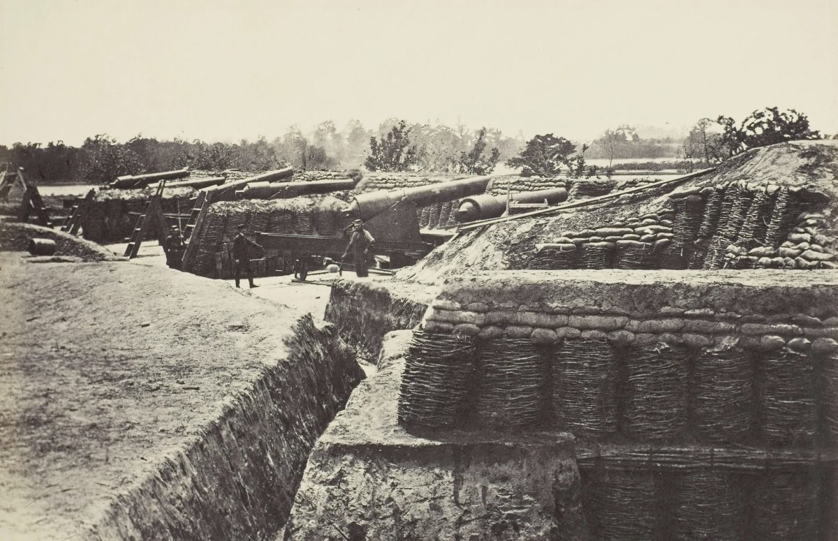
To demonstrate the strength of sand, which results from intergrain friction between tiny, hard, sharp quartz fragments, Gillmore ordered “penetration” tests, firing all sorts of small arms at typical defensive material like timber, muddy sod, and sandbags. The sand proved best at slowing incoming projectiles in every case, and sand proved even more effective at diminishing the shock effects of larger exploding shells. Sand also doesn’t lose any effectiveness when repeatedly struck by bullets or shells, unlike wood or brick.

European countries later began using iron in their shore fortifications to deal with advances in technology and more effective naval artillery. The cash-poor United States couldn’t afford these upgrades and stuck with sand. Massive reinforced concrete structures buried in sand seemed to be the most cost-effective manner to protect our shorelines.
Tell us about Dennis Hart Mahan. How did his parapet construction assist in warfare?
Mahan was trained as an engineer and instructed many officers from both sides of the conflict while he was chairman of West Point’s Engineering Department. His work on the design and construction of fortifications was a required part of the curriculum for 50 years. Mahan’s greatest contribution was his ability to clearly disseminate many of the lessons taken from European battlefields, including the use of combined arms and the design of permanent and field fortifications.
His Treatise on Field Fortifications outlines in great detail the proper plans for constructing a parapet for defensive purposes. He stated plainly that all “intrenchments” or fieldworks had three general purposes. First, it was critical that all works provide defensive cover. Second, they should provide improved firing positions for the defenders. Finally, they should prove a hindrance for the attacking force or “present an obstacle to the enemy’s progress.” The simplest way to meet all three criteria was to dig a long ditch and use the excavated sediment to construct an embankment, or parapet. The ditch provides an obstacle, and the parapet provides both an obstacle and protection and, if constructed properly and of the correct materials, an enhanced and raised firing position.
Mahan thought of his earthen fortifications as both a defensive force multiplier and a structure that could be critical for offensive tactics as well. Sheltered defending troops could provide a decisive counterattack after a failed assault against their works, striking the retreating enemy when their command structure was in disarray.
From what were most of Mahan’s structures made?
This is a surprisingly complicated question, one that I dedicated about 10,000 words to answer in the book. In short, the ratio of sand, clay, and cobbles in an earthwork can alter everything from how durable the structure is with respect to erosion to how well it resists penetration from enemy artillery shells. For example, a parapet constructed purely from quartz sand can absorb an immense amount of shellfire before losing effectiveness, but it will be especially prone to natural erosion. This is because the sand possesses a great degree of intergrain friction, but little natural cohesion. If clay is added to the sand, it will be more cohesive and erosion resistant, but it loses some of the ability to withstand incoming artillery rounds (and a parapet will be more challenging to repair). If cobbles are added to the superior (outside) slope of the parapet to reduce erosion, you have introduced a new secondary projectile that can be especially dangerous when struck by incoming fire.
When sand is piled for defensive purposes or when trenches are dug in clay-poor soils, some measure of revetment or reinforcement is needed to keep the sediment in place. Mahan spent almost as much time describing different kinds of revetments, including wood, marsh sod, gabions, and sandbags as he did discussing the proper properties of earth. I’ve always thought it interesting to consider how much military technology has changed from the Civil War to the present day, but sandbags have remained essentially consistent in both construction and use.
In regard to the Civil War parapets of Mahan’s design, no combination of sand, silt, and clay could survive the mobile firepower available during World War I. The result was that earthworks changed from piling sediment to create a parapet to digging into the earth, essentially providing no visible target for the enemy’s artillery. This introduced all new types of complications from porous and permeable sediments (and groundwater infiltration) and the need for extensive reinforcing and revetting.
How did gabions work?
A gabion was constructed of sticks in a basket-form with flexible half-inch twigs used to tie them together. These cylindrical wicker drums were around two to three feet in diameter and three feet high. When filled with sediment they could stop a bullet or offer support for an overly steep slope. Often, for example, the interior slope of a parapet was lined with gabions. By the end of the war the interior of Fort Sumter was held in place by hundreds of large gabions that were filled with brick rubble.
One major drawback to using gabions occurred when fine dune or beach sand was used as fill. On Morris Island, South Carolina, for example, gabions were replaced by federal sappers with sandbags when the fine sediment was found to leak from between the interlocking sticks.
The U.S. military still uses gabions extensively, although they are no longer a stick-based defensive measure. The HESCO Mil, essentially a modern gabion, was introduced during the First Gulf War. The HESCO system consists of a collapsible steel wire mesh lined with a polypropylene geotextile and filled with local sediments. These structures offer more protection that the woven basket-of-branches gabions from the Civil War, while also being significantly simpler to assemble and fill.
Explain what Napoleon’s quote about mediocre troops means?
I included Napoleon Bonaparte’s assessment “With mediocre troops one must shift much soil” as the first quote in the new book because it summarizes so perfectly the need for properly constructed field fortifications when working with inexperienced soldiers. While Union and Confederate infantry certainly did not suffer from a lack of courage, they were, for the most part, far from professional soldiers. In many instances troops entered combat with less than a month of drilling— the very definition of a “citizen- soldier.” In combat, any type of protection, whether a parapet, split-rail fence, linear trench, rifle pit, or preexisting stonewall, would offer some perception of protection, allowing a soldier an amplified sense of security. More confident soldiers performed better when fighting and were more likely to deliver effective rifle fire. They were also more likely to follow the command to counterattack if the circumstances dictated. The length of time required for reloading single-shot muzzle-loader, and the need to stand while doing so, only increased the sensation of vulnerability and increased the value of cover and protection. Concealed and protected soldiers were also, obviously, harder to maim and kill by an attacking enemy.
I’ve heard that there is an entire 20-minute portion of the new Napoleon film in which Joaquin Phoenix discusses the sedimentology of the battlefield of Austerlitz, but this could be wishful thinking.
Tell us about the sedimentary rocks and unconsolidated sediments that underlie the battlefields from the Coastal Plain.
There is great variability in the sedimentary geology under the Coastal Plain battlegrounds, and a key factor determining the amount of sand, silt, and clay you will find is the site’s proximity to either the Fall Line, to the west (and north), or the coastline, to the east (and south). The Fall Line is the contact between the hard igneous and metamorphic rocks of the Piedmont and the Plain’s much less durable sedimentary rocks and sediments.
Many key cities straddle the Fall Line, including both wartime capitals, so it is no surprise many battlefields are found on or near this geologic contact. Generally, the closer you are to the Fall Line, the more consolidated (rock-like) are the sedimentary layers. Underlying Fredericksburg and the Seven Days’ battlefields are some of the Coastal Plain’s oldest and most durable clay-rich units, resulting in undulating terrain cut by stream valleys and river terraces. Hills and ridges are usually formed by clay-rich, highly compressed mixtures of sand and silt, and are more durable to weathering and erosion.
For battlefields farther from the Fall Line, like Bentonville or Morris Island, sand reigns; the terrain is especially flat. Entrenching is also fairly easy, though the sand requires much revetting. I argue in the book that the strongest defensive position occupied during the war was not on high, hard rock like Little Round Top or Kennesaw Mountain, but rather Lee’s position at Fredericksburg, where he organized his infantry and artillery along high, but slightly weaker, sedimentary strata (when compared to nearby igneous or metamorphic rock). These layers of sediment are tough enough to resist erosion, so they are elevated and dominate the surrounding landscape, but soft enough to allow digging. The geology allowed excellent sight lines and establishment of rifle pits and protected gun emplacements above a flat river terrace.
Talk about the “Fiasco at Fredericksburg.”
At Fredericksburg, Ambrose Burnside attacked a strong position across open ground on a flat river terrace a dozen times in piece-meal fashion. If that wasn’t enough of a Federal “fiasco,” what Burnside did less than a month later certainly qualified.
Fresh off his army’s great defeat at Fredericksburg, Burnside proposed crossing the Rappahannock with a surprise flanking movement and trapping Lee against the river’s west bank. Lee’s geological advantages would be largely mitigated and Burnside would be between the Confederates and their capital. But then it started to rain.
As the Federal units started moving west, more than three inches of freezing rain fell across the region and onto the absorptive clay-rich soils. This type of soil is called a Ultisol and is known for trapping water near the surface, minimizing deeper infiltration and producing standing water. Fields and roads become exhausting to cross and everything sank into the mud, including wagons, cannons, and mules. Churning by men on the march made things even more difficult.
On January 22, the rain stopped, yet somehow the situation became even more insufferable. Burnside wavered on whether to continue and it got colder. The mud, lubricated by the addition of massive amounts of rain, rendering it exceedingly slippery, now became more adhesive, sticking to everything. Men lost their boots; wagons became impossible to move; and misery increased. On January 26, with morale at a new low, Lincoln relieved Burnside of his command.
Tell us about Scott’s Anaconda plan along the Eastern coast.
When General-in-Chief Winfield Scott proposed what would be known as the “Anaconda Plan,” his goal was to isolate the south and divide the Confederacy into two parts by moving down the Mississippi River. The nickname alludes to the image of a giant snake surrounding and suffocating the southern ports.
There are a multitude of ways that sedimentary geology made the success of the plan and the Union blockade more challenging. For example, from a naval perspective, major trading centers like Wilmington were more difficult to blockade than it might appear. The presence of the Frying Pan Shoals, an unpredictable and treacherous sand body extending from the mouth of the Cape Fear River for more than 20 miles offshore, meant that two different naval squadrons would be required to suppress the city, and these units would not be able to support each other because of the sedimentary obstacle.
Sedimentary geology also made capture of the “Father of Waters” more difficult. Strongholds like Grand Gulf, Port Hudson, and Vicksburg were all carved into an unusual sediment called loess, a weakly-cemented silt that is ideal for entrenching and erodes into vertical cliffs. These qualities were exploited by the rebels to create massive, complex defensive entrenchments and elevated gun batteries above the river.
Even Flag Officer David Farragut’s fleet, attempting to move up the Mississippi past New Orleans, was hindered by sedimentary geology. His largest ship, the Colorado, was left behind in the gulf because she drew too much water to pass over the river’s sand distributary bar. In contrast, sediments did help with Farragut’s tactics when attacking Forts St. Philip and Jackson below New Orleans. To prepare his vessels for a night attack, dark Mississippi mud was smeared on the side of the boats for camouflage and sand was spread on the decks for traction in water or, inevitably, blood.
What was the fate of the fortifications?
In Sand, Science, and the Civil War, I outline the differences in preservation potential between permanent and temporary fortifications. Permanent fortifications like the brick citadels of Forts Pulaski, Morgan, Pickens, and Sumter were constructed during peacetime in (presumably) geologically stable environments. It was anticipated that they would survive natural threats for a century or more, and most have. Fort McRee, constructed to protect Pensacola’s harbor, was an exception, having been eroded into the Gulf of Mexico by beach drift, sea-level rise, and storms. (Note that the later batteries of reinforced concrete from the Endicott Era that protected this same portion of the shoreline were often completely buried in Gulf Coast sand for additional protection.)
For temporary fortifications, which were constructed expeditiously during the war and lost a great deal of their strategic value when the fighting moved elsewhere, their fate is more perilous. Farmer’s plows and urban sprawl have destroyed many field fortifications. Some of the best soils for constructing earthworks are also, unfortunately, the most fertile.
Temporary fortifications are constructed of, or dug into, local sediments. Sand piled along the shoreline (Fort Fisher, Batter Wagner) or along rivers and bluffs (Island No. 10, Vicksburg’s batteries) are especially vulnerable to natural erosion. Coastal sand forts were also sited to take full advantage of barrier island geology and were often built very close to sea level to take advantage of ricocheting fire across the water. As a result, almost all have been lost because of sea-level rise, beach drift, storms, and antropogenically derived erosion (from jetty construction, for example).
Most lower-gradient rivers like the Mississippi also meander through soft sediments, a perfect destructive agent for temporary earthen fortifications that have no possibility of being relocated. As a result, fortifications like Fort Hindman and Island No. 10 have been completely lost to these highly dynamic environments.