How Europeans let most of America slip out of their hands
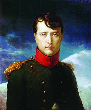
EARLY IN April 1803, Napoleon Bonaparte was in Paris at the Tuileries, his official residence as First Consul. France’s leader was in his bath, soaking in rosewater cologne, when in burst his brothers, visibly agitated. Lucien and Joseph Bonaparte had come to dissuade their sibling from selling Louisiana to American President Thomas Jefferson. Each brother had his reasons.
Lucien Bonaparte had led recent talks that returned the territory from Spanish to French control. Regaining the huge region of Louisiana had been Lucien’s crowning personal achievement. Selling the gigantic property, and to the Americans at that, would erase his historic work.
Joseph Bonaparte had more practical worries. He feared Napoleon would sell Louisiana without consent from France’s still-powerful Chamber of Deputies, which had sway to send all three brothers to the deathtrap that was French Guiana for arrogating so much authority to themselves.
The Bonapartes were at odds because after only two years, the Peace of Amiens, an intermission in the Napoleonic Wars, was crumbling. The Little Corporal was eager to resume fighting, and to finance that aggression he had put Louisiana on the block. Until recently, Napoleon could not have done so. In 1763, France, defeated in the Seven Years War and wishing to keep the British from getting their hands on Louisiana, had ceded the enormous parcel to Spain.
But Napoleon came to imagine a French empire in the Caribbean, fed by France’s holdings in America’s western regions. To advance this scheme, he had Lucien negotiate the return of Louisiana. In 1801, the First Consul had sent his brother-in-law, General Charles Leclerc, to reconquer San Domingue, the western district of Hispaniola that had overthrown French rule and declared independence, renaming itself Haiti.
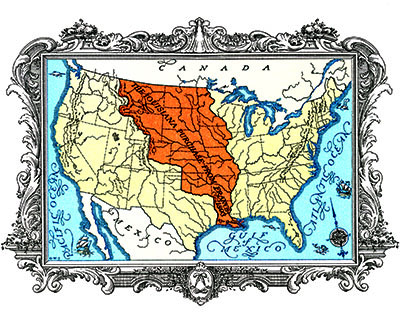
However, yellow fever and Haitians—but mainly yellow fever—had killed Leclerc, 50,000 of his soldiers, and the First Consul’s New World ambitions. Hence the First Consul’s fire sale to Jefferson of all French-held land north of Spanish-held Texas. The price was $15 million. The acreage involved in the transaction was unmeasured.
The Americans had not started out trying to buy Louisiana; they wanted only New Orleans. Since the 1780s, American farmers west of the Appalachians reached European markets by shipping produce down the Ohio and other tributaries to the Mississippi and on to the port. In 1798, Spain closed New Orleans to American vessels. The sanction infuriated Trans-Appalachian states, which had made clear to President Jefferson that if he did not open New Orleans and its wharves they were prepared to do so by force.
The argument in the imperial bathroom grew fierce. Joseph Bonaparte threatened to lead opposition to selling Louisiana in the Chamber of Deputies.
The First Consul burst out laughing.
“Laugh, laugh, laugh, then!” Joseph said, advancing on the tub. “I will act up to my promise; and though I am not fond of mounting the tribune, this time you will see me there!”
Napoleon rose, naked and pink. “There will be no debate,” he told his brothers. “The project which has not the fortune to meet your approval, conceived by me, negotiated by me, shall be ratified and executed by me alone, do you comprehend?—by me, who laughs at your opposition.”
“I am beginning to think he is much too fond of war,” said Joseph to Lucien. After more vituperative back and forth, their brother abruptly plopped back into his scented bath, splashing his siblings with rosewater—Joseph so thoroughly that he left to change clothes.
The First Consul got his way.
On April 30, 1803, Jefferson’s representatives, Robert Livingston and James Monroe, suddenly, unexpectedly, and for a mere $15 million, gained title not merely to the city of New Orleans but all of the western expanse of Louisiana. Napoleon returned to making war. The Louisiana Territory became American, without him or any other Frenchman knowing its extent or contents.
No one did, really.
It took surprisingly long to inventory what we think of as America. Most Europeans had a grasp of South America, at least in outline, well within the century after Columbus reached its shores. Western North America’s basic shape remained unknown until the mid-1700s. The great Spanish galleons plying between Manila in the Philippines and Acapulco in Mexico certainly touched on the continent’s western coast. However, the Spanish did not establish missions and presidios north of Baja California until the 1760s, and then primarily in response to Russian fur traders drifting south from Alaska in the late 1700s as Russian trappers depleted northerly sea otter populations. Coming south looking for hunting grounds, the Russians got to within 50 miles of San Francisco Bay, establishing a colony at Fort Ross in 1812 and naming a stream near there the Russian River.
But the Spanish did not publish their maps and western Europeans knew nothing of Russian cartography. Spain and Russia only skirted America’s westernmost edge, the Russians eventually withdrawing to Alaska, their North American holding. White men did not encounter the Sierra Nevada mountains until 1776. Indian and Spanish sources spoke of a north-south cordillera—but the location of the range known today as the Rockies was uncertain. The era’s geographers, in thrall to the “theory of symmetry,” assumed that what held true in the East also applied in the West. They expected western cousins to the Appalachians—old, worn, perhaps a half-day’s passage to cross. It was known that the West was home to great rivers—the Colorado, the Rio Grande, the Missouri—which, because of their wide mouths and huge output, obviously had to flow across enormous landscapes. A fourth stream emerged in 1792, when American ship captain Robert Gray sailed slightly up a great river he named the Columbia.
Of these rivers’ watersheds, no one knew anything.
Each Indian tribe was intimate with its home turf. However, although the Spanish and the French and the Russians had claimed parts of the West, and Great Britain coveted it, no imperial explorer, no Cook or Cortés, had ventured into the region, traversed it, mapped it, catalogued its elements. Maybe the West did have great silver mines like those in Mexico. Maybe the Missouri and the Columbia did converge, or at least were adjacent. A river system connecting Atlantic and Pacific could provide that shorter, easier passage to India that Europeans had been seeking since Italian explorer Giovanni da Verrazano’s day in the 1500s. Almost as soon as European nations became aware of the West, the locale became a vessel for imperial dreams, imagined to harbor civilizations, precious metals, resources, populations, and species not yet conceivable. When Thomas Jefferson sent Meriwether Lewis and William Clark and their Corps of Discovery into the void, the president had his scouts on the lookout for mastodons as well as “Welsh Indians.” These primitives, a medieval tale had it, had left Wales in the mists of time to follow a “Prince Madoc” west into the Atlantic, never to return but possibly to prosper.
Until the Corps, the blank on the map that was the American West could be filled only by dreams. All stabs at exploration had failed or been abandoned. But why?
The Spanish tried first. Subduing Peru and Mexico, which the conquistadors called New Spain, soldiers of the empire next worked their way into and through Mexico’s northern deserts. The Southwest saw the first, most extensive attempt at penetration. Conquistador Francisco Coronado, primed by Spain’s successes elsewhere in the New World, ventured in search of the seven golden cities of Cibola.
In the Spain of the 800s, a much-told tale went, seven bishops, beset by rampaging Moors, had led parishioners west into the ocean. On Antilla, a mysterious island, the refugees supposedly built seven cities. Latter-day searches failed to turn up Antilla, though sailors named a Caribbean archipelago stretching from Cuba to Trinidad the Antilles after the mythical isle. Similarly, when in 1510 Spanish novelist Garci Ordonez de Montalvo published Las Sergas de Esplandian (The Deeds of Esplandian), he partly set his story on an island of Amazons ruled by Queen Califia and called California, the name explorers would give to the gulf created by a peninsula jutting along Mexico’s Pacific coast.
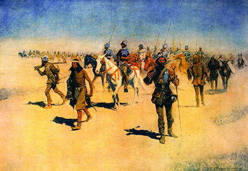
Like the name “California,” the chimera of the seven cities persisted. Gesturing northward, Indians in Mexico told conquistadors about seven metropolises, distant and wonderful. What could these be except long-sought Cibola? After the Aztecs, after the Inca, here might await another countinghouse of gold and silver. In 1540, New Spain’s government sent Coronado into the northern desert with 1,000 men on foot and horseback and 600 pack animals. Like Columbus, Coronado believed he was entering a land contiguous to “greater India.” He found no cities, but he did find villages. Zuni and other tribes, generally welcoming, stood in awe of those horses. Whatever impulse Indians had to resist faded in the face of the overwhelming power flaunted by the brutal, demanding Spanish.
Coronado’s goal was gold, not geographical knowledge. The force he led encountered a native whose dress and look led the Spanish to nickname him “the Turk.”
The Turk spoke of a river “with fish as large as horses” transecting a land whose lord “took his rest under a large tree from which hung numerous golden jingle bells, and he was pleased as they played in the wind.” Common people there ate from dishes of wrought silver, while “the pitchers, dishes and bowls were made of gold.”
Where was this place, the Spanish asked. At Quivira, the Turk replied. He led Coronado northeast through what became Texas and into what is now Kansas. No gold or silver appeared; nothing “but cattle [buffalo] and sky,” a soldier said. Coronado described “plains so without landmarks that it was as if we were in the middle of the sea.” The Turk admitted he had led his new masters into the wild at the behest of other Indians. Returning to New Spain in 1542, Coronado faced a court of inquiry whose officers told him what he already knew: his expedition had been a resounding failure. He had found no gold, a massacre by Coronado’s men had ravaged a pueblo, and Spanish behavior had so alienated natives that they were murdering Franciscan missionaries.
Coronado’s failure discouraged Spanish exploration for two generations. Not until 1610 did settlers come to Santa Fe, in the colony of New Mexico. That site evolved into a major trading post, but aside from minor excursions into Texas the Spanish did scant further probing and none north of Santa Fe. For 200 years Spain regarded the far west—hot, bone dry, thinly populated, short of resources—as a thousand-mile barricade keeping other Europeans out of northern Mexico.
France based its claim on what it called Louisiana, for King Louis XIV, on a 1682 voyage down the length of the Mississippi by Rene-Robert Cavelier Sieur de la Salle, who declared that river and its valley a French holding. La Salle hoped that the big stream was the Grail-like “river to the West” said to lead to the Orient, and that it drained into the Gulf of California. Through the 1700s, the French labored under this and many other wrong-headed myths, but they got one thing right: the extent to which northern Mexico would enrich Spain. Between the 1500s and the 1700s, mines in Peru and Mexico together yielded 100,000 to 150,000 tons of silver. That trove, nearly 90 percent of world production, annually underwrote nearly two-thirds of Spain’s budget. The French imagined burrowing into northern versions of the peaks in Mexico and South America to find riches of their own.
But France’s New World wealth turned out to have four legs and marvelous fur. By the 1730s, voyageurs from the east and north trapping beavers and other species had penetrated to the vicinity of Lake Superior. Seeking information on what lay west, the formidably named Pierre Gaultier de Varennes et de La Vérendrye interrogated Indians.
Talking geography with Indians was tricky. The aboriginals mapped land in their minds far differently and more flexibly than did Europeans, with their exacting bird’s-eye cartography. Confusion abounded. Indians had nearly as many languages as they had tribes. And none of those languages was written; the region’s universal mode of communication was sign language. Following his investigations, La Vérendrye reported to Paris that he had learned of a riviere de l’Ouest—“a great river which flows straight toward the setting sun, and which widens continually as it descends.”
Whoever found that river had found the path to the Pacific, the French thought.
La Vérendrye did not find the riviere de l’Ouest, but he did discover Lake Winnipeg, explore central Canada, and reach the Dakotas. Asking Mandan Indians in the Dakotas how to get to the western ocean, he learned nothing. Indians stayed close to home except when firm trade relationships maintained peace. Tribes told the Frenchman about lakes that ebbed and flowed and about waters that were undrinkably salty—all hearsay and invention. The river that flowed straight toward the setting sun, scholars think, was probably the Nelson—but the Nelson flows east into Hudson Bay. There, in the 1740s, the British wasted men, ships, and time hunting their idea of the route to India, a Northwest Passage that would have cut 6,000 miles from the sail around South America—if such a passage had existed.
The Aztec and Inca cultures had created empires, complex and effectively organized civilizations. Subjects of each spoke a single language, and their existing systems of administration lent themselves, after conquest, to regime change. Aztec bark-cloth maps, not unlike European counterparts, showed rivers and communities. The Inca had stitched their lands with roads, and all spoke Quechua, still the lingua franca of South America’s highlands.
Not so in the North American wilderness.
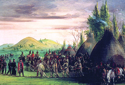
Crossing those featureless western plains, Coronado encountered a new and unfamiliar language each time he entered a town. Across the west lived independent tribes speaking different tongues, or pidgin variants—23 along the Colorado River alone. Only trade and sign language knit tribes to one another, and then loosely. Tribes might raid back and forth all winter, taking scalps and stealing mounts, slaves, and food, yet at another season meet peaceably to trade horses for corn and corn for guns. Wintering at Fort Mandan on the Missouri, one of the men with the Corps of Discovery fashioned axes that he traded to Mandan for corn. Moving on, Lewis and Clark came upon one such tool in another tribe’s hands, borne ahead of them by Indian commerce. Unlike Mexico and Peru, the West had no overarching system, no organizing principle, no management in place on which conquerors could build.
Beholding the hugely profitable fur trade that had become their principal North American enterprise, French diplomats dreamed of undiscovered civilizations, of silver and gold mines, of rivers to the Pacific. Refracting Indian lore, French mapmakers conjured a Sea of the West the size of the Mediterranean opening onto the Pacific near San Francisco Bay. Yet the French investigated no further west, instead simply tallying their profits on beaver and lynx. By 1763, when France ceded Louisiana to Spain, Frenchmen were still dawdling in the Dakotas. The Spanish then let that vastness lie, a fallow tract obstructing the expansionist British Atlantic colonies brawling into the lands between the Appalachians and the Mississippi River.
During Spain’s 40-year hegemony in Louisiana, French fur traders in that region built settlements along the Mississippi and ventured up the Missouri. By 1803, Frenchmen were working traps in North Dakota. When Lewis and Clark left St. Louis in 1804, they engaged voyageurs as guides.
For Thomas Jefferson, the Louisiana Purchase marked a huge relief.
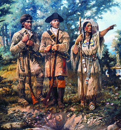
Jefferson had long had imperial dreams, picturing a United States stretching to the continent’s western antipodes. He dreaded the thought of seeing a European power perched on the Mississippi’s west bank. To Jefferson it must have seemed providential, a manifestation of national destiny, that the West stayed so empty and so unknown for so long when the French had been so close in the north and the Spanish in the Southwest and California. On their voluntary forced march, Lewis and Clark made real Jefferson’s vision. They encountered Sioux, Blackfoot, Nez Percé—who briefly considered killing the whole bunch of them—and persevered, all the while logging data. The explorers took most of a year to ascend the Missouri River, then nearly starved in the Bitterroot Mountains on a 100 mile-plus portage from the Missouri’s headwaters to a navigable tributary of the Columbia. Hike by hike, paddle by paddle, river crossing by river crossing, ascent by ascent, they shattered geographical myths.
Even after the Corps of Discovery reached its westernmost longitude, America was still a long time in the discovering. Not until 1846 did an army succeed in crossing and acquiring for the United States the empty quarter that so frustrated Coronado. Another huge foreign-owned parcel came into American hands in 1867, when Russia sold Alaska to the United States for $7.2 million, less than half of what Napoleon had charged for Louisiana. Alaska became a new frontier, but discovery in America proper was still afoot in the 1880s, when the Rockies and the Sierras reluctantly yielded their last secrets.
It is hard to imagine now that the United States might have developed into a middling republic sharing a continent with French, Spanish, or British—even Russian—commonwealths. But history is not providential. History is accidental. Had Napoleon Bonaparte’s brothers persuaded him to change his mind—and the First Consul came close to doing so—who knows what language folks might be speaking in Seattle or Denver or Kansas City right now? ✯
This story was originally published in the August 2017 issue of American History magazine. Subscribe here.