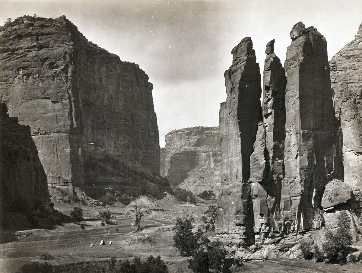
Canyon de Chelly, in the Four Corners region of northeastern Arizona, is among the most spectacular natural wonders of the American Southwest. It is also one of the longest continuously inhabited places in North America. Archaeologists estimate humans have lived in the canyon for more than four millennia. By the late 17th century Navajos had made their home there, and in the 19th century they waged two battles in Canyon de Chelly central to tribal history.

The canyon floor is anywhere from 100 to 300 yards wide and flanked by sheer red rock walls up to 1,000 feet high. About 3 miles from its east entrance the canyon splits into two main branches, with Canyon del Muerto running off to the northeast. Five miles up Canyon del Muerto is another junction at a prominence called Fortress Rock. Black Rock Canyon splits off due east, while Canyon del Muerto courses another 15 miles northeast.
In January 1805 a force of 500 Spanish soldiers under the command of Lieutenant Antonio Narbona entered Canyon de Chelly in response to a Navajo raid against the Spanish military post at Cebolletta. In the resulting battle near the northeast end of Canyon del Muerto the Spanish claimed to have killed 115 Navajos, including 90 warriors, while taking 33 women and children as slaves. Navajo tradition relates a different story—that most of the warriors were away hunting that day, and almost all of those killed were women and children. As the Spanish troops approached, the Navajos sheltered in a cliff dwelling high on the canyon wall, where they were trapped and picked off by Narbona’s marksmen. The only Spanish casualty was a soldier tackled by a Navajo woman while he was scaling the cliff. Both fell to their deaths. Narbona ended his career as the fifth Mexican governor of New Mexico.
Fifty-nine years later the Navajo fought another battle in Canyon de Chelly, this time against the United States. While the Civil War was raging east of the Mississippi, the U.S. government sent troops to the Southwest to put an end to persistent raids by emboldened Navajos. In 1864 Brig. Gen. James H. Carleton, commander of the military Department of New Mexico (which spanned what today comprises New Mexico and Arizona), ordered Lt. Col. Kit Carson of the 1st New Mexico Volunteer Cavalry to clear the canyon of Navajos and relocate them to a reservation at Bosque Redondo, nearly 400 miles southeast at Fort Sumner, New Mexico Territory.

That January 12, in the face of a blinding snowstorm, Carson led 389 troopers into Canyon de Chelly. The Navajos, under the leadership of Chiefs Barboncito and Manuelito, skillfully used skirmishing parties to fight delaying actions while their main body withdrew into Canyon del Muerto. On reaching the junction with Black Rock Canyon, they scaled Fortress Rock with the help of ladders prepared ahead of time. By the time Carson’s force reached the far end of Canyon del Muerto, it had destroyed the tribe’s camps, crops and supplies and taken more than 200 captives. But more than 1,000 Navajos had evaded to the top of Fortress Rock, where they had stockpiled food. It wouldn’t be enough.
Biding his time, Carson withdrew from the canyon to wait out the Navajos, who were bereft of the necessities to survive winter. The strategy worked. By that summer Carson had accepted the surrender of some 8,000 Navajos, the largest such capitulation in American Indian history. In its wake the Navajos were forced to make what they recall as the “Long Walk” to Bosque Redondo. But the tactical success for the U.S. government turned out to be a strategic failure in the end. Some 3,000 Navajos died at the meagerly supplied reservation before they were finally allowed in 1868 to return to their homeland in the Four Corners region.
Present-day Canyon de Chelly (pronounced “de SHAY”) National Monument lies entirely within the boundaries of the Navajo Nation, thus all visitors to the canyon floor must be accompanied by a licensed Navajo guide. Its sheer walls are pocked with the ruins of centuries-old cliff dwellings and etched with pictographs. A particularly striking 200-year-old pictograph on the wall below Massacre Cave depicts the invading Spanish cavalry force, replete with lances and cross-bearing tunics. The North Rim Drive provides a number of spectacular overlooks, including Antelope House Overlook (directly across from Fortress Rock) and Massacre Cave Overlook, while the South Rim Drive ends at an overlook of the 750-foot sandstone spire known as Spider Rock. There is just no substitute, however, for exploring the canyon floor with a knowledgeable guide, one for whom it is especially personal hallowed ground.
This story appeared in the 2023 Summer issue of Military History magazine.
historynet magazines
Our 9 best-selling history titles feature in-depth storytelling and iconic imagery to engage and inform on the people, the wars, and the events that shaped America and the world.