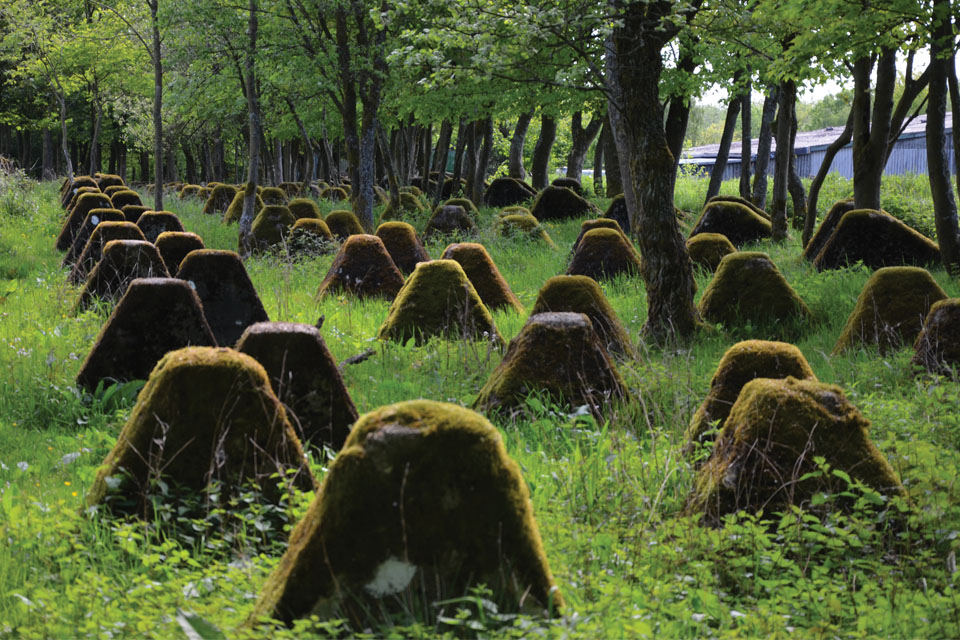
Dairy farms, immaculate homes, and healthy cud-chewing brown cows dot the countryside south of Aachen, Germany, a few miles east of the Belgian border. But a short drive later the peaceful scene transforms, as row after row of ominous four-foot-tall stone trapezoids—huge zigzags of concrete molars called dragon’s teeth—stretch across grassy fields.
German workers created these formidable-looking obstacles, among the vestiges of Adolf Hitler’s vaunted Westwall, to impede invader tanks and machinery. Intrigued by these strange structures, my friend David and I—both military historians living in Brussels—decided to make the Westwall the target of a weekend exploration. Leading us was Peter Drespa, a former Bundeswehr staff sergeant and tank commander turned professional battlefield guide. Drespa specializes in conducting tours of the vast area where the Battle of the Bulge raged and beyond. He lives in North Rhine-Westphalia, near the Belgian section of the Westwall and within range of Bastogne, where GIs survived a weeklong siege in December 1944.
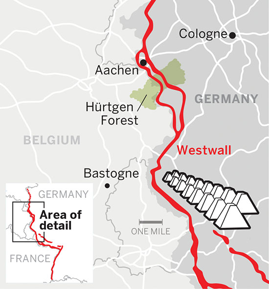
The Westwall is better known outside Germany as the Siegfried Line—named after a similar German defensive perimeter of First World War vintage—and dates to 1938. That year, Hitler assigned Reichsminister Fritz Todt, the architectural genius who created Germany’s autobahns, to erect barricades to keep enemies from attacking the Reich through France and Belgium. Hitler insisted on having tidily linear fortifications, so Todt set to work, requisitioning huge resources. His immense labor pool included 1,000 private subcontractors organized into 22 brigade-size units totaling 340,000 men. In addition, Todt appropriated 90,000 fortress engineers and soldiers from the Wehrmacht’s Army Group II, plus 100,000 uniformed men from the Reichsarbeitsdienst—the National Labor Service.
The Westwall is a labyrinth of defenses that includes forward and rear trenches and clusters of pillboxes covering their approaches. It runs nearly 400 miles from the Netherlands to Switzerland. We started our stroll through Todt’s handiwork at a hamlet six miles south of Aachen, as our guide explained his motivation for roaming former combat zones. “It gives me a chance to tell younger Germans about the mistakes Germany made and how the country was hijacked by Hitler and the Nazi Party,” said Drespa, who in his soldiering days worked with many Americans. “I enjoy meeting American veterans and their children on these tours.”

On a cold and daunting winter morning we began our tour with a short drive south to a lush valley bisected by miles of eerie objects poking out of the mist. We spent six hours clambering around 16 bunkers, tank traps, antiaircraft emplacements, and, of course, dragon’s teeth. The air smelled of silage and pine as I absorbed the enormity of Hitler’s fortifications. They are extremely well built—a mile and a half of dragon’s teeth contains 7,128 cubic yards of concrete and 193 tons of reinforcing rods—too large and too extensive to remove, so neighbors live with the old Reich’s wreckage.
Brush, weeds, moss, and lichen coat many of the dragon’s teeth, but others shine bright white, as though they were newly cast. Trees infest stretches of the barriers, reclaiming them for the forest. In his research trips along the barrier, Drespa has located more than a dozen arrays of dragon’s teeth—in German, Drachenzähne —as well as many other wartime remnants.
As we study the battleground, our vision sharpens, bringing into focus perfectly preserved bunkers located in yards, bogs, pastures, and dugouts in banks overlooking rail lines. Defenses speckle the land. Drespa likes to shepherd clients around Westwall structures repurposed as outbuildings, sheds, and barns. He waves at farmers as we cross their land, cheerfully calling out, “Guten Tag!” They wave back from their doorways, hoisting steaming cups of coffee. Everyone knows Peter Drespa, illustrating the wisdom of hiring a local guide.
While we traverse parallel lines of emplacements, Drespa explains their roles. Bunkers with interlocking fields of fire and tank traps are everywhere, positioned to destroy tanks and infantry. The bunkers were so well camouflaged in 1944 that GIs often unwittingly stood right in front of them. Some are still difficult to spot and so well designed that, as Drespa observes, they continue to influence contemporary defensive architecture.
The concrete structures we visit are a mixed bag. Some are punched deeply into the ground, their walls and floors studded with rusting pumps, generators, and ventilators. In residential backyards, bunkers languish, abandoned or demoted to storing tools. A few carry scars: pocks and holes made by small-arms fire and artillery.
Allied troops had paid dearly trying to broach the Westwall, where they suffered about a third of their casualties in Western Europe. The U.S. Army’s 28th Infantry Division lost 1,500 dead or wounded riflemen in one week fighting in the Hürtgen Forest. The U.S. 84th Division tallied 2,000 casualties taking the heavily fortified section of the Westwall at Geilenkirchen.
Later, we ascend into the alpine forests of the Eifel-Ardennes Mountains. Alongside the ubiquitous dragon’s teeth lay jumbles of torn and broken concrete that look as though a giant had taken a truck-sized hammer to them, and more bunkers—some as large as a house—that British Army engineers partially demolished.


against Allied aerial attacks.
In the Schnee-Eifel—the initial scene of the German counteroffensive that became the Battle of the Bulge—we hike half a mile into the forest. Apart from our boots crunching on the snow, silence reigns. We arrive at four-foot deep circular concrete pits spanning ten paces across, some filled with rubble. Deep rectangular indentations mark some interior walls in these emplacements—ammunition magazines.
“Antiaircraft?” I ask. Drespa nods. They are Hermann Göring’s legacy—a standing testament to his strategy to protect the area from enemy aerial attacks. These defenses stand a few miles behind the forward portion of the Westwall. Where two emplacements adjoin, an open trench lined with concrete connects them. This allowed gunners to move back and forth between guns protected from Allied aircraft. Now almost brimful of earth, the passages have sizeable pines and firs growing from them.
At each pit’s center is a circular gun platform, once home to an antiaircraft gun. As Drespa conducts us around the pit, he describes how he helps locate aircraft downed nearby during the war. He also participates in recovery efforts aimed at finding MIAs. In the Eifel-Ardennes alone, the record shows 2,100 American MIAs. Drespa has helped pinpoint more than 200 felled aircraft, some with remains still inside. Germans at these very emplacements might have shot them down.
In the end, the domineering Westwall proved to be pregnable after all. Hitler pooh-poohed the need to reinforce forests, swamps, and rivers that presented natural barriers, leaving these poorly defended locales for Allied troops to exploit—which they did with minimal casualties. In one instance, on September 15, 1944, an Allied task force south of Aachen advanced unopposed past ghostly, silent pillboxes, emerging into open country beyond the Westwall. It took them only three days to pass through what Todt had spent years building.
As the tour came to an end, we fell silent, awed by what we had seen. Deserted pillboxes belied the explosive and bloody events of over 70 years ago. The Westwall tells its history in concrete and rebar—a lasting monument to the conflict that spawned it. ✯
This story was originally published in the September/October 2016 issue of World War II magazine. Subscribe here.