It’s one of the best-known stories of the Civil War: Confederate General Thomas J. “Stonewall” Jackson is accidentally shot by his own men during the Battle of Chancellorsville and then dies a few days later. His death, perhaps, alters the course of the war itself.
Today, visitors to the Chancellorsville battlefield can walk the ground where Jackson’s story unfolded—but appearances can be deceiving. The land has changed. The environment has changed. The ambience has changed. The ground does not tell the story as clearly as it once did, and even Jackson’s own legacy has added to the difficulty of appreciating the extent to which darkness and confusion reigned on the night of May 2, 1863—and what an unlikely accident Jackson’s wounding really was.
After fighting on May 1, Union Maj. Gen. Joseph Hooker had placed his Army of the Potomac in a defensive position around the crossroads of Chancellorsville, Va. Hooker anchored his army’s left flank on the Rappahannock River, 2.5 miles northeast of the crossroads; to the west of Chancellorsville, however, the army’s right flank hung in the air along the Plank Road, also known as the Orange Plank Road. The Federal right flank was nearly two miles from Hooker’s headquarters at the Chancellor House.
For his part, General Robert E. Lee realized he faced far superior numbers—Hooker still had about 70,000 troops—so he sent scouts to look for a weak point in the Union line. The scouts soon discovered the unprotected Union right flank.
That night, seated on a pair of cracker boxes by a campfire, Lee and Jackson hatched a plan. Lee, with 14,000 men, would hold Hooker’s attention. At the same time Jackson, with more than 28,000 men, would slip around the front of the Union army and hit its vulnerable right flank.
The resulting march lasted nearly all of May 2. By 5 p.m., only two of Jackson’s three divisions were in position. Jackson couldn’t afford to wait for Maj. Gen. A.P. Hill’s division, still coming up. He had only a few hours of daylight to make his assault.
Jackson’s battle line centered on the Plank Road and stretched past each side of the road for half a mile. When the line swept forward, it caught the Union army’s XI Corps, under the command of Maj. Gen. Oliver Otis Howard, completely by surprise. While some Federal units stubbornly resisted the attack, the Confederate advance inexorably rolled forward some 1.5 miles.
“So complete was the success of the whole maneuver, and such surprise of the enemy, that scarcely any organized resistance was met with after the first volley fired,” Brig. Gen. Robert Rodes recalled. “They fled in the wildest confusion.”
Union battery commander Hubert Dilger did his best to slow the Confederate advance, as did XI Corps brigade commander Colonel Adolphus Buschbeck, who threw up a west-facing line of infantry and artillery near the Wilderness Church to meet the Confederate threat. But it was the terrain more than anything that slowed the Confederates. This area was known as “the Wilderness”—70 square miles of dense, tangled forest. Iron furnaces had been processing the area’s rich iron ore reserves since the mid-1700s. To fire the furnace boilers, owners had clear-cut the surrounding forests and used the timber for fuel. By the 1860s, though, a thriving second-growth forest of pucker brush, thick bushes, thorn-covered vines and plenty of scrub had sprung up. The trees, on average, were 30 feet high. Union soldiers said sunlight would not penetrate to the forest floor, even at the brightest point of the day.
This forest absorbed much of the sound of the Confederate advance. While many Union soldiers heard the Rebel Yell that accompanied the initial attack, not one mentioned hearing the bugle calls that signaled it. Likewise, Union commanders farther down the line didn’t hear the attack on the XI Corps and didn’t know about it until Howard’s soldiers began retreating past them, nearly a half hour after the assaults began.
If noise couldn’t penetrate the dense vegetation, humans didn’t fare much better. Trying to stay in battle formation was nearly impossible. Some units advanced faster than others as soldiers got caught in the tangles and tripped on the vines. The uneven terrain compounded the difficulties. Hills and gullies, knolls and swales, all hidden by the brush, further impeded their progress.
“We could see absolutely nothing of the enemy, nor of any other part of our own lines,” recalled Confederate Major Robert Stiles; “indeed the entire region was a gloomy thicket and our infantry line so stretched and attenuated that the men were scarcely in sight of each other.”
“We could not see what was going on around us for the brush,” wrote Private David Holt of the 16th Mississippi. “[T]he fighting was hot and close” because of “the thick underbrush.”
In an attempt to rally the men of the broken XI Corps, the 8th Pennsylvania Cavalry rode into the fray—west along the Plank Road and running headlong into Jackson’s men. The 8th was thrown into disarray, losing three officers, 30 men and 80 horses before cutting their way out. The presence of those horsemen on the battlefield would have indirect but nonetheless important repercussions later in the evening.
By 8 p.m., the last traces of sunlight vanished. Although a full moon soon rose in the clear sky, the Wilderness, with its thick foliage, was a place of shadows. The one exception was the Plank Road, which came west from Fredericksburg as the main thoroughfare and along which the Union line had originally been formed. Part of the road was macadamized with crushed gravel, which shone white in the moonlight.
The Confederate advance had, by this point, reached the Plank Road’s intersection with a country lane called the Bullock Road. Here, the 18th and 28th North Carolina regiments, supported by the 50th Virginia, extended the Confederate line northeast, with the right flank of the 18th North Carolina resting on the Plank Road itself. On the south side and a few hundred feet to the right rear, the 37th and 7th North Carolina regiments extended the Confederate line south. The 33rd North Carolina, thrown out in a wide arc in front of the entire formation, served as skirmishers.
Jackson’s keen eyes saw an opportunity in the midst of the tangled forest. He could continue pressing the attack forward along the Plank Road, or he could veer to the northeast along the path of the Bullock Road, allowing him to cut off the Federals’ escape back to U.S. and Ely’s fords. With the Union army then trapped between Jackson and Lee, Jackson’s men could serve as the hammer to crush the Federals against the anvil of Lee’s forces. Regardless of which option he chose, Jackson knew he had to maintain the initiative. If he halted his attack until dawn, Union infantry could dig in overnight. Jackson did not want to attack fortified positions in the morning.
As he weighed his options, Jackson decided to get a first-hand look at the situation. But the impenetrable darkness of the Wilderness presented a challenge. The Plank Road offered the only clear path for travel.
Jackson soon learned of an alternative, however. His guide, Private David Joseph Kyle of the 9th Virginia Cavalry, told him of a road that “ran sorter parallel with the plank road and came out on it about a half a mile below.” The Mountain Road was an old logging road less than two miles long. It didn’t show up on maps, but Kyle knew the road well; he and his family lived on the Oscar Bullock Farm, which sat at the far end of Bullock Road.
Jackson, Kyle and seven others rode forward on the Mountain Road, passing through the line of the 18th North Carolina. Jackson’s party rode about 200 yards forward, not quite reaching the 33rd North Carolinians in their skirmish line. Jackson could hear the Federals, not far to the east, digging in. It was all he needed to know.
As Jackson turned back toward his line, several important things were happening almost simultaneously. Not far away, Hill was doing some reconnaissance of his own. He did not have a local guide, however, and did not know about the Mountain Road, so he and his nine-
member party took the more exposed route along the Plank Road, almost parallel with Jackson.
Farther down the Confederate line toward the south, a lost Federal unit, the 128th Pennsylvania Infantry, wandered into the no-man’s land between the skirmishers of the 33rd North Carolina and the main Confederate line. The Pennsylvanians were quickly captured, but their presence, which had been undetected by the skirmishers, left the Confederates on edge.
Soon a Federal horseman showed up, sparking a firefight. Spooked, the far right of the Confederate line opened up, firing mostly at nothing—and like a contagion, more and more Confederates joined in the shooting. The wave of musket fire rolled north along the Confederate line.
The rolling thunder first caught Hill’s party, exposed in the moonlight out on the Plank Road. Only Hill himself was unscathed; everyone else in his party was killed, wounded or carried toward enemy lines on the back of a bolting horse.
The fire also ripped across Jackson’s front.
“Cease firing! You are firing into your own men!” yelled Lieutenant Joseph G. Morrison, Jackson’s brother-in-law and staff member, whose horse was shot in the initial volley.
The North Carolinians were veterans who’d seen every trick—and besides, hadn’t Federal cavalry been caught behind the lines just hours before? There were dead horses and horsemen near the road and in the woods. And weren’t these horsemen coming from the direction of the Union lines? “It’s a lie,” the North Carolinians responded. Another volley erupted.
Jackson was around 90 yards from the front line. At that range, a smoothbore musket has about a 1-in-16 chance of hitting its target—and that’s if the shooter has a clear range of fire. Jackson’s party was riding through a thick forest, in the dark. Jackson would have cut an especially dark figure because he was wearing a long, black India-rubber raincoat. The roadbed had, over the years, cut into the earth so that it ran a few yards below the level of the surrounding terrain; that road embankment essentially served as additional protection. “[T]he thickness of the woods afforded some shield,” too, one of Jackson’s staffers later said.
Still, one staffer was killed and another wounded; the others escaped untouched—except, of course, for Jackson.
The circumstances had been ripe for disaster: a corps commander scouting in front of his lines; soldiers deploying in the forest, in the dark, in a pitched battle; lost infantrymen and horsemen wandering through the woods; the threat of a Union counterattack at any moment.
Still, the chances of Jackson getting shot were incredibly small. So how and why did it happen?
Those questions have been debated and discussed for 150 years. The story has been recounted and analyzed in letters, books and scholarly articles—some of them more reliable than others.
But fewer things can shed light on the story like walking the ground.
Years later, as the legend of Stonewall Jackson grew, people wanted to track down the exact location where Jackson was wounded. But there was considerable disagreement and uncertainty. Eyewitness and second-hand accounts varied. To some of Jackson’s admirers, marking the exact spot wasn’t as important as marking the general area. Sometime between 1876 and 1883, those admirers placed a granite boulder—the “Jackson Rock”—along the Plank Road, not the Mountain Road, so it would be visible to tourists and travelers.
In June 1888, admirers erected a more formal monument just 20 feet away. James Power Smith, one of Jackson’s former staff officers, helped choose the spot. “When we were selecting a location for the monument,” he wrote, “the present site was selected, as being on the [Plank] road—somewhat elevated—and as being a fair compromise…. It is only a few rods from the exact spot wherever that was.”
Today, a large hedge blocks a traveler’s view of all but the very top the monument. But its presence behind the Chancellorsville Battlefield Visitor Center—and the original granite bolder 20 feet away, placed after the war to mark the vicinity of Jackson’s wounding—can serve as a source of confusion to uninformed visitors.
Eventually, the Mountain Road vanished. At least one account from 1903—only 40 years after the battle—suggests the ever-encroaching forest had swallowed the road by then.
Traces of the road were further obscured when the visitor center was built in 1963. The National Park Service’s philosophy then was to put visitor centers as close as possible to the most pivotal portion of the battlefield. The Chancellorsville Battlefield Visitor Center sits astride the original path of the Mountain Road, and only by luck did the building not obscure the spot where Jackson was wounded—although for years, Park Service historians were convinced Jackson had been shot in the corner of the visitor center’s auditorium.
As recently as the mid-1990s, historians differed on the exact place where Jackson was shot. The issue was finally put to rest when a team of historians, led by Robert K. Krick and armed with dozens of pieces of documentary evidence, mapped and measured the entire area. They found, nearly lost among the trees, the old roadbed of the Mountain Road, and they were able to pinpoint Jackson’s location—some 15 yards off the northeast corner of the visitor center. Today, a newly installed wayside sign stands across the road from the spot.
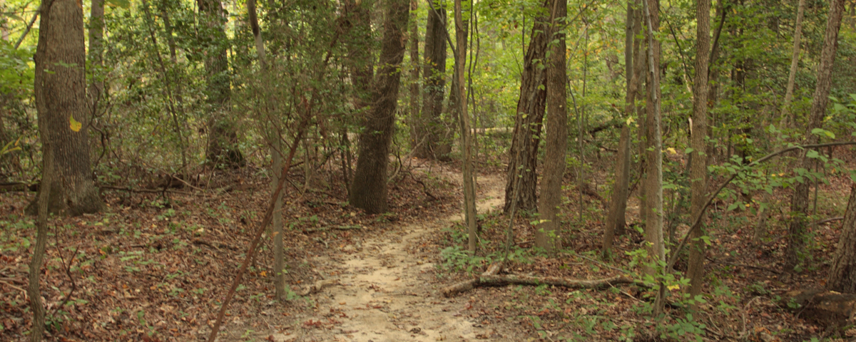
The Mountain Road underwent restoration in 2007, making it more visible to visitors who can now walk part of its length. At the far end, another wayside marks the farthest point of Jackson’s reconnaissance trip. Another 50 yards through the woods beyond that, about where the visitor center’s driveway comes into the parking lot from Virginia Route 3, is where the skirmish line of the 33rd North Carolina had been positioned.
Battlefield visitors can retrace Jackson’s last ride—from that farthest point of his reconnaissance, then back along the Mountain Road toward where the visitor center now stands. And when visitors emerge from the canopy of trees that arches over the road, they will stand on the spot where Jackson was mortally wounded.
Even so, what they see provides an incomplete picture of what really happened. First of all, modern visitors cannot truly appreciate the nature of the Wilderness. Recent development has cleared away most of the forest, creating the impression of far more open space than actually existed in 1863. Housing developments, gas stations and shopping centers—not to mention the widened Route 3—belie the once-wild nature of the area and obscure some of the key areas on the battlefield. The site of the 8th Pennsylvania cavalry charge, for instance, is now a private resort just down the road from the park’s visitor center.
What forest remains has had 150 years to mature. The trees are much taller, and the high canopy casts heavy shadows, choking out all but the most shade-loving plants. There are fewer ground-level plants than in 1863, so the brush is far less dense.
Trees and brush have been thinned in the area around the battlefield visitor center so that there’s considerable open space. In some places, there’s even well-trimmed lawn punctuated by a few tall maples. Standing at the spot where Jackson was wounded, one might think he was exposed and vulnerable. Bullock Road—the location of the Confederate line—is clearly visible fewer than 100 yards away, and aside from the visitor center itself, there’s not much in between.
From the Bullock Road, it would seem Jackson and his party were emerging from a tunnel of trees into an open area. In the moonlight, the horsemen would still be little more than silhouettes—easily mistaken for Federal cavalry. But in May 1863, the line of sight from Bullock Road to Jackson was impenetrable. The only open view was directly down the Mountain Road itself. That means six to eight men at most—the men standing at the intersection of the Mountain Road and the Bullock Road—had a clear shot at the approaching horsemen. The other 290 or so men of the regiment would’ve been shooting through dense thickets.
The ground around the visitor center muddles the story of Jackson’s wounding in another important way. The building itself sits on a hillock, which may suggest to some visitors that Jackson had a degree of cover or, conversely, that he “sprang up” from behind the hill as he crested it.
Mountain Road did rise slightly as it neared the Bullock Road from the spot where Jackson was wounded, but postwar photographs indicate that, overall, the ground was fairly level. That means the North Carolinians would have been looking slightly downhill into the cut of Mountain Road with no intervening mound of dirt.
But Mountain Road itself poses the greatest challenge to trying to imagine the events of that night. It is nearly impossible to get a clear sense of road conditions when Jackson was wounded—for starters, the battlefield closes at dusk and hiking after dark is prohibited. The high canopy of the modern forest does blot out most of the light from even a full moon, but the openness underneath belies the claustrophobic thickness that pressed in on Jackson and his men from the roadsides.
Given the four lanes of traffic on Virginia Route 3, there’s never a shortage of noise on the battlefield, which, again, affects our ability to understand the environment of 1863. The traffic makes it impossible to appreciate the acoustical shadows—the places where the sounds of battle couldn’t carry—that plagued the Union army. As the Confederate wave advanced and battle raged nearby, areas of the battlefield remained silent. Such silence is impossible to find today.
With any battle, walking the ground can help to better understand what happened and why—and Chancellorsville offers many such opportunities. But Jackson’s story has been confounded by changes to the site. Those changes have allowed visitors easier access to one of the war’s most famous spots—and if the landscape isn’t exactly what witnesses saw in May 1863, at least the story is still there. It just needs to be coaxed out.
Kristopher D. White, former Fredericksburg and Spotsylvania National Military Park staff historian, is an instructor at the Community College of Allegheny County, Pa. Dr. Chris Mackowski, a professor in the School of Journalism and Mass Communication at St. Bonaventure University, is author of Chancellorsville: Crossroads of Fire. They are co-founders of Emerging Civil War, a website for the next generation of Civil War historians, and co-authors of several books.