

Two maps of the battle of Gettysburg. The first map depicts the battle itself, showing the positions of the Union and Confederate positions by day, July 1 – July 3, 1863. The second map shows the overall Gettysburg, Pennsylvania campaign, showing the movements of the Confederate army from Virginia, through Pennsylvania, and into Gettysburg.
Battle of Gettysburg Map
Map by Baker Vail. Taken from "Did Robert E. Lee Doom Himself at Gettysburg?" MHQ: The Quarterly Journal of Military History Summer 2009
[singlepic id=1274 w=250 h=325]
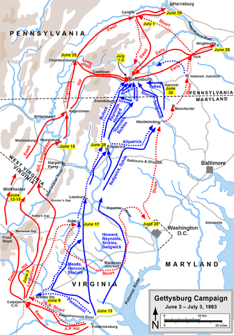
Battle of Gettysburg Campaign Map
Map by Hal Jespersen, www.posix.com/CW, via Wikimedia Commons.
Learn more about the battle of Gettysburg, the single largest battle ever fought on U.S. soil.
Read more about the Battle of Gettysburg