Maps and Mapmakers of the Civil War, by Earl B. McElfresh, Abrams, New York, 212-206-7715, 272 pages, $55.
Maps and Mapmakers of the Civil War is more than a coffee-table book of beautifully reproduced Civil War maps. Besides the striking illustrations that Stephen W. Sears calls “art” in his foreword, author Earl B. McElfresh provides a scholarly depiction of the crucial work of Civil War mapmakers and analyzes the complicated process that made the maps possible.
In designing the maps, engineers used color to express geographic features, but the use of color also encouraged the engineers’ artistic inclinations. John S. Clark, who served on Union General Nathaniel Banks’s staff, made extraordinarily artistic, though militarily unreliable, maps. He painted his maps of the 1864 Red River Campaign in Louisiana with vibrant watercolors skillfully shaded to show elevation.
Some artistic tendencies served important military purposes. Others had little effect on a map’s usefulness, but at least made the cartographer’s work more pleasant to view. Confederate topographical engineer Jedediah Hotchkiss spent an inordinate amount of time preparing highly detailed maps for Lieutenant General Thomas J. “Stonewall” Jackson. Hotchkiss, like most of his contemporaries, believed graphic maps were easier for a military commander to comprehend.
A wide range of maps appears in Maps and Mapmakers. One of the best is Hotchkiss’s exquisitely drawn map of the central Shenandoah Valley, which Jackson used during his 1862 campaign in that part of Virginia. Among the less famous works in the book is a faulty map of 1862 Virginia that Colonel William F. Small sketched from a Union observation balloon. While this flawed work has little value beyond its novelty, most of the maps did manage to combine artistic flair with military purpose.
Some of the maps appear so small that only their general appearance is appreciable. In the case of John N. Macomb and William H. Paine’s map of northeastern Virginia on November 13, 1862, and William E. Merrill’s topographical map of the December 1864 Battle of Nashville, the details of the maps are obscured. The battle lines on Merrill’s map barely appear. In McElfresh’s defense, the offending maps are reproduced close to their actual size.
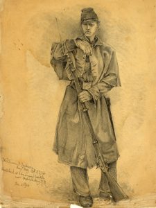
The more functional purpose of military maps requires serious consideration. The goal of the cartographers’ creations was to guide military movements. McElfresh uses the writings of Jedediah Hotchkiss, D.H. Strother, author Ambrose Bierce, and other contemporary sources to illustrate the process of mapmaking and the importance of accurate maps.
The process of gathering information to make effective maps was, at its best, very thorough. Topographical engineers often rode on horseback toward enemy lines, where they sketched on drawing boards propped on their saddle pommels. They questioned local citizens and studied roads, military fords, woods, hills, and other landmarks that were potential focal points on the battlefield. Measurements proved crude, but sufficient, as the engineer’s need to travel light demanded that better, heavier equipment be left behind.
In Maps and Mapmakers of the Civil War, McElfresh sought to achieve two objectives: to reveal the artistic dimension of mapmaking and to demonstrate the importance of the mapmakers’ work. The book achieves both, making it a welcome addition to the scholar’s bookshelf. Maps and Mapmakers of the Civil War is an atlas with a twist, however, as McElfresh does not allow the maps to stand by themselves. By supplying valuable contextual material, especially excerpts from memoirs, he brings out the experience of Civil War cartographers. His work sheds light on the behind-the-scenes work required to wage four bloody years of Civil War.
Steven E. Nash
Western Carolina University