LOCATED ON A NARROW island that separates Galveston Bay from the Gulf of Mexico, Galveston, Texas, in 1900 was a prosperous port of 37,000. Residents had bragging rights to a number of Texas firsts: the first medical college in the state, the first electric lights and streetcars and the first public library all belonged to their city. Its illustrious past seemed to bode well for its future—until the deadliest hurricane in U.S. history changed things forever.
On Wednesday, September 5, 1900, the Galveston Daily News ran a tiny, 27-word squib in its weather section: A tropical disturbance was moving over western Cuba and heading for the south Florida coast. The notice was datelined “Washington, D.C.,” September 4. It was simply signed “Moore.” That was Willis Moore, director of the United States Weather Bureau.
Three days later, with no official warning, a Category 4 hurricane leveled Galveston and claimed at least 10,000 lives. The unnamed storm is still the deadliest in American history.
Accurate long-range tracking of hurricanes was hard to come by in 1900. But Moore’s notice was so wrong—about the nature of the storm and its direction—that it seems to suggest both meteorology and international communications remained in a primitive state. Nobody, one might assume, knew anything in advance about the hurricane’s strength or track.
But that’s far from the truth. As early as Monday, September 3, the storm was being observed by meteorologists in Cuba. They were perhaps the best in the world at assessing and predicting the tracks of hurricanes, and they knew the storm had grown into an unmistakably violent one headed for the Texas Gulf Coast. Why didn’t the U.S. Weather Bureau know that? The grim answer to that question had to do with a highly problematic relationship between the United States and Cuba following the Spanish-American War.
Cuban revolutionaries, assisted by the United States, had won independence from Spain in 1898. Yet in September 1900, the U.S. government still administered the island, and within the U.S. Weather Bureau, which had stations in the Caribbean, resentment and disdain for Cuban forecasting had become entrenched.
Meteorology, like much other science in Cuba, was the province of Jesuit priests. The Belen Observatory, founded by Father Benito Viñes in Havana in 1858, was perhaps the most advanced in the world. An extension of a Jesuit preparatory school, the observatory benefited from the long Jesuitical tradition of inquiry, experimentation, publishing and teaching.
There couldn’t have been a better place to learn how to forecast bad weather than Havana. Its tropical vegetation, wrought-iron balconies and painted stucco houses were routinely subjected to torrential downpours and violent wind. One year, a hurricane removed the observatory’s entire zinc roof.
Father Viñes hoped not only to advance meteoro-logical science but also to aid humankind. He soon made the small Havana observatory the hub of a forecasting network for the entire Caribbean Sea. He filled a storm notebook with descriptions of clouds, cross-referenced to instrument readings. He jotted down snippets of conversations with ship captains. He brought in telegraph reports and newspaper clippings.
From these data, Viñes created a system for understanding storm formation and making predictions. He published it all in newspapers so that ordinary people could understand and respond. But his real genius lay in interpreting the meaning of cloud formations and how they related to hurricanes: cirrostratus clouds and their plumiform type in particular.
Cirrostratus are high, gauzy clouds composed of ice crystals. They give a kind of cover through which a haloed moon may be seen or from which hazy sunshine emanates. Viñes realized that hurricanes tend to produce these cirrostratus clouds—but only on the outer edges of a system. He began to suspect that those clouds are created by winds flowing off a hurricane system miles high. So if you were to see cirrostratus clouds in the tropics, Father Viñes deduced, you might really be seeing the farthest outer edge of a hurricane, which you wouldn’t otherwise have any idea was out there. Because hurricanes are so massive—hundreds of miles across—the far outer edge may lie many days’ travel away from the storm’s deadly eye.
You know a hurricane is coming. And you still have time to act.
But not all forms of cirrostratus cloud signal the approach of a distant hurricane. The clouds must come in plumiform shape; that is, they appear to spread across the sky, fanning upward in plumes that seem to be reaching out from a central point. The bottoms of these elongations, Viñes further deduced, point directly at the eye of the hurricane that produces them.
So now you also know the direction from which the hurricane is coming.
Using those theories, Father Viñes built a model by which meteorologists could accurately ascertain that a hurricane had formed, calculate roughly how far away it was, gauge how fast it was moving and even closely track its path. Soon he had a telegraphic network of storm observers working the entire Caribbean, integrating reports from every kind of colonial and independent government: Spanish, British, French, Danish, Dutch, Dominican, Venezuelan and American. Everything about Caribbean weather went through Father Viñes in Havana and traveled through telegraph weather networks in which the United States also participated.
AT THE U.S. WEATHER BUREAU in Washington, D.C., director Willis Moore made squelching Cuban forecasting one of the most important reforms he brought to the office. The bureau had been established as part of the U.S. Army’s Signal Corps in 1870; when Moore took it over in 1895, he was determined to make it a model of efficiency. Perhaps most important, he tightened the rules concerning local forecasting—especially regarding storm warnings. Moore believed local weathermen had been over-warning the public. There was a tendency to sow panic. It created an unhappy impression that the bureau was not fully in control. From now on, all storm warnings would come from Moore at his hub in Washington. The local weathermen would cable regular temperature, atmosphere and wind condition reports to the central office, where clerks aggregated the morning data into a national weather map, which was then telegraphed back to each station. It was for Washington, not for local weathermen, to determine what was going on locally.
And for fear of panicking local populations, Moore banned certain words from all official weather reports: “Tornado.” And “cyclone.” And “hurricane.”
Moore also assigned Colonel Henry Harrison Chase Dunwoody, an officer in the old Signal Corps, to the bureau’s Caribbean weather station. Colonel Dunwoody had made his name by scoffing at the value of meteorological science in making predictions, especially when it came to hurricanes. The source, progress and ultimate course of a hurricane might as well be, according to Dunwoody, “a matter of divination.” To the Americans, Cuban forecasts seemed hysterical, despite their extraordinary history of accuracy. The superstitious lore of a backward people, the bureau believed, lacked the Yankee grit and know-how that was making America a great leader on the world stage.
So Moore and Dunwoody appointed one of their own to assert a big, strong, guiding American presence in Cuban forecasting: William B. Stockman, a veteran of the bureau going back to the Signal Corps days. Stockman set up shop in Havana and took charge of all the U.S. weather stations in the region. In one of his early reports, Stockman simply eradicated the entire history of the Cuban weather networks. He told Moore that Cubans had never heard of forecasting. The locals were “very very conservative,” Stockman reported, “and forecasting the approach of storms…was a most radical change.” It was especially important, Stockman advised, that the bureau not be guilty of causing “unnecessary alarm among the natives.”
And there was yet another problem with the Cuban weathermen. The Havana observatory, Stockman claimed, had been secretly piggybacking on U.S. reports. Agents in the bureau’s New Orleans station nabbed copies of the daily weather maps coming out of Washington, then sent the U.S. maps by undersea telegraph to Havana. Such shifty shenanigans allowed the Cubans, as Dunwoody put it, “to compete with this service.”
In other words, the Cubans never got things right, but when they did, it was because they stole U.S. data. Having pinched good reports, the Cuban forecasters whipped a silly, uneducated, overemotional population into frenzy with overblown warnings of monster storms.
IN LATE AUGUST 1900, Moore decided to deal once and for all with the Cuban annoyances. Hurricane season was well underway. This was the perfect time, Moore calculated, to shut down all communication between Cuban weathermen and the people of the United States. It would take some string pulling. Fortunately for Moore, the U.S. War Department controlled all of Cuba’s government-owned telegraph lines. Those were the same lines over which Father Viñes had established his fabled hurricane-warning system for the entire region. The War Department responded quickly to the Weather Bureau’s request to formally ban from those lines all messages referring to weather.
But Moore went further and banned direct communication between the U.S. Weather Bureau’s office in Havana and the office in New Orleans. Havana would report directly to Washington, and Washington would decide what information to give New Orleans and the rest of the Gulf Coast.
Moore even reached out to Western Union, the commercial telegraph company. He couldn’t demand that Western Union censor private weather-related messages, but he could ask the company to manage what a later age would call bandwidth. He requested first priority for U.S. Weather Bureau transmissions. Next would come any non-weather-related messages. Cuban weather mes-sages were to get the lowest priority. Western Union showed a patriotic willingness to cooperate. Any private telegrams from Cuba to the United States regarding weather would be slowed, bumped or, Moore hoped, discarded. His blackout of Cuba was almost total.
On Monday, September 3, Father Lorenzo Gangoite, who had succeeded Father Viñes in Havana, observed a new storm. He saw that it was changing fast, twirling on its own axis as it zoomed across the spinning Earth—yet it hadn’t formed that perfect, and perfectly deadly, spiral that we associate with a hurricane. There wasn’t yet an eye of low pressure at the system’s center. Its winds, while hard and rough, still did not reach above 60 mph.
The storm nevertheless already had the power to knock down buildings and wash away train tracks on Cuba and other islands. Late Wednesday night, September 5, Father Gangoite observed a big halo around the moon. The halo did not dissipate. At dawn, the sky turned red—deep red—and “cirrus clouds,” Gangoite said later, “were moving from the west by north and northwest by north, with a focus on those same points.” To him that meant the storm had transformed drastically: It had gained intensity; it had gained structure; and prevailing winds were pushing it northwest. Following Father Viñes’ model, Father Gangoite thought he could tell exactly where the storm was going: the Texas Gulf Coast.
There was nothing Father Gangoite could do. Willis Moore had blocked the forecast. But he couldn’t stop the hurricane.
AT 6 A.M. THURSDAY, September 6, the people of Galveston, Texas, were looking forward to the weekend and hoping for relief from the heat. Everything certainly looked fine—if still and humid—when Isaac Cline, the Weather Bureau’s chief Galveston observer, took the morning readings from the top of the five-story Levy Building downtown. Barometric pressure within the normal range. Light winds. Temperature already 80 degrees—hot, but slightly cooler than it had been. The huge sky over the Levy Building and out to the calm Gulf was as clear and blue as could be.
At 8 a.m. the bureau confirmed the prediction it had telegraphed to Galveston the day before regarding a disturbance coming out of Cuba. “Not a hurricane,” Moore called it. (Evidently, you could use the word as long as you put “not” in front of it.) The course of this non-hurricane would not affect Galveston. The storm would instead go into a classic “recurve.” According to the bureau, storms exiting the Caribbean on a northerly trajectory could not continue on a northwestern track. A storm thundering out of Cuba over the Florida Straits must turn toward Florida, where it would sweep across the peninsula. Broken coastline on the Florida side of the Gulf would prevent the storm from hitting any landmass head-on, and it would lose what little power it had. The system, said the bureau, was “attended only by heavy rains and winds of moderate force” that could damage moored ships and shoreline property along the Florida coast. The storm would then move northeast, weakening as it went, and probably would “be felt as far northward as Norfolk by Thursday night and is likely to extend over the middle Atlantic and South New England states by Friday.” After that, the storm was expected to exit into the Atlantic somewhere in or above New England.
Weather stations at New Orleans and points east were authorized to hang the red-and-black storm-warning flags, letting ship captains know of moderately disturbed seas. But any residual action in the Gulf would quickly dissipate. And no warnings were in order west of New Orleans. Some fishermen on the New Jersey shore, having received the national report, cabled Moore for advice. Never one to hesitate, Moore cabled right back. “Not safe to leave nets in after tonight,” he warned them. A rough storm was headed their way, Moore was certain.
Moore was correct in believing that many hurricanes do “recurve.” But there also happened to be, at that moment in September 1900, a big zone of high pressure bordering the Florida Keys—that string of narrow islands curving from the tip of the state’s long peninsula—well to the east of the storm. This high-pressure zone caused an exception to the rule of hurricane recurve that Willis Moore thought was immutable. A recurve would have drawn the hurricane east toward Florida, but high pressure at the Keys pushed it away. Winds blowing from east to west off the Keys added to the pushback.
Drawing new energy constantly from the hot sea below, pulling those waves high upward, throwing wind in every direction as it circled, unleashing monstrous thunderclaps and streaks of jagged lightning and pouring hard rain, this complex of storms was also drawn west-northwest by low pressure there. Spinning counterclockwise, it had become a fully organized system of destruction turning around a large, roughly circular eye, some 30 miles in diameter.
At 1:59 p.m. Cline received a telegraphed report from Washington. The storm that had drenched Cuba was now, as expected, centered over southern Florida. That evening, in Galveston, Cline took the last readings for the day. It was hotter now—just over 90 degrees. The wind was out of the north. The barometer was down—but just barely. There were scattered clouds. Cline reported all of that to Washington and went home to bed.
Friday morning, September 7, everything stopped making sense. The Weather Bureau abruptly reversed its forecast, and Cline was ordered to raise the storm-warning flag. What Cline didn’t know was this: The weathermen in Washington had been getting surprising reports from local stations on the East Coast. The stormy weather predicted there had entirely failed to arrive. The winds that battered Key West did not start blowing in central Florida after all. Savannah and Charleston were not being drenched. Those fishermen in Long Branch, N.J., worrying about their nets had nothing to fear. There was only one conclusion. The men in Washington finally drew it. The storm that had left Cuba on Wednesday must still be in the Gulf of Mexico.
In Galveston Friday afternoon, a heavy swell formed southeast of the long Gulf beach. And it arrived with an ominous roar. The clouds, meanwhile, were coming from the northeast. Obviously, a severe storm was on the way. Thanks to the storm-warning flag, as well as to the crashing surf on the beach, the Weather Bureau office on the third floor of the Levy Building had become a scene of constantly ringing phones and people crowding in with questions. Ship captains, the harbormaster, businessmen and concerned citizens, official and civilian alike, wanted answers. While officials in Washington had recognized they were wrong about the storm’s track, on one point Moore remained insistent: This couldn’t be a hurricane.
All day Isaac Cline and his brother, Joseph, tried to fend off confusion and worry. They took turns dealing with the phones and the crowds and collecting weather data on the roof. The clouds had thickened. The day that had started clear was now cloudy. From out in the Gulf, the swells kept coming. By Friday night, rain had started falling steadily and Joseph Cline had a sense of impending disaster. He’d received reports from New Orleans, the weather station nearest to the center of the storm. It was southwest of the city and moving west.
Joseph knew that meant it was heading straight for Galveston.
About midnight, Joseph quickly created a new weather map based on the reports he was receiving by cable. He took the map to the post office to await the first train over the railroad bridge from Galveston Island to the Texas mainland. Then he went home to the house he shared with Isaac about three blocks from the beach and tried to sleep. Visions of hurricanes kept invading his dreams.
At 4 a.m. Saturday, September 8, he awoke with a start. He had a sudden, clear impression that Gulf water had flowed all the way into the yard. Joseph got up. From a south window, he peered down.
It wasn’t a dream. The yard really was under water. The Gulf was in town.
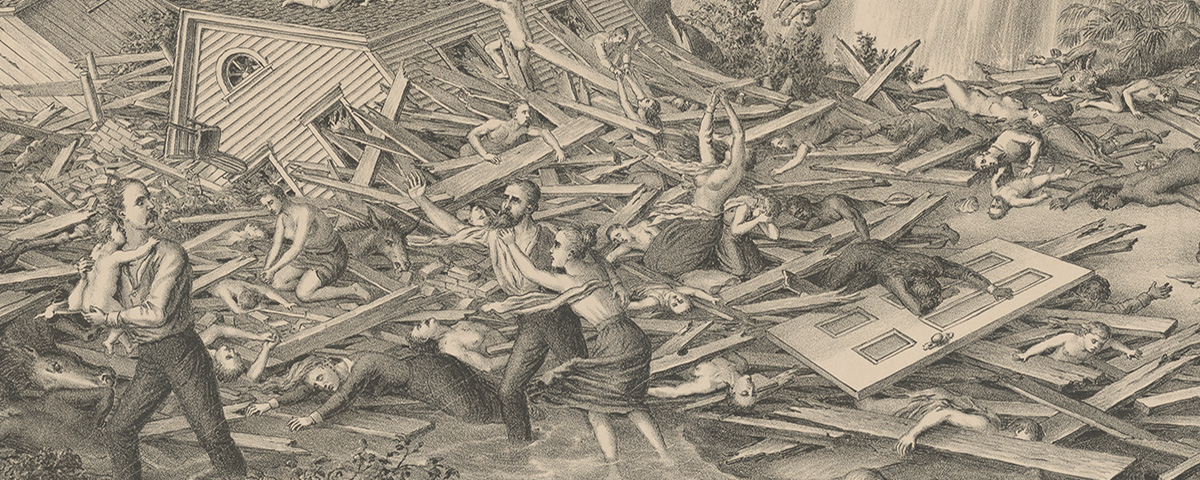
EPILOGUE: Defying the ban on local storm warnings, Isaac Cline sprang into action, urging beach residents and business owners to head for higher ground. But the highest point in Galveston was 8.7 feet above sea level, and the island was about to be engulfed by a 15-foot storm surge. At 3:30 Saturday afternoon, the Clines sent a cable to Moore in Washington. “Gulf rising rapidly,” it read. “Half the city now under water.”
Fifty people sought refuge in Cline’s stout brick house, which was knocked off its foundation Saturday night. All but 18, Cline wrote later, “were hurled into eternity,” among them his wife, Clara, pregnant with the couple’s fourth child. (The Clines’ three other daughters survived.) Across Galveston, the devastation was unimaginable: an estimated 6,000 dead in the city and another 4,000 to 6,000 on Galveston Island and the adjacent mainland. Property damage at the time was estimated to be $30 million; in today’s dollars, that’s more than $700 million.
Willis Moore suffered no professional consequences for his decisions. On September 28, 1900, he commended the Clines and their assistant, John Blagden, for “heroic devotion to duty. . . .Through [your] efficient service…in the dissemination of warnings, thousands of people were enabled to move…and were thus saved.” The Weather Bureau slowly adopted hurricane-forecasting techniques in the coming years (though tornado warnings were officially banned until 1938). Moore was fired from the Weather Bureau in 1913 after charges of improper conduct in his campaign to secure a Cabinet post were referred to the Justice Department.
[hr]
From the forthcoming book The Storm of the Century: Tragedy, Heroism, Survival, and the Epic True Story of America’s Deadliest Disaster, the Great Gulf Hurricane of 1900, by Al Roker. © 2015 by Al Roker. To be published August 11, 2015, by William Morrow, an imprint of HarperCollins Publishers. Reprinted by permission.