 U.S. Army Corps of Engineers |
|
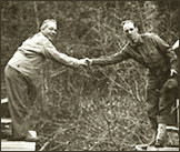
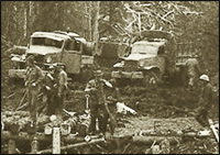
A bulldozer of the 340th Engineers, Northern Sector, meets the lead clearing dozer of the 35th Engineers, Southern Sector, near Watson Lake, Yukon Territory to complete the linking of the sectors and provide a road from Fort St John to Whitehorse, Yukon Territory.
|
 U.S. Army Corps of Engineers |
It’s difficult to imagine road-building conditions any worse than those workers faced in 1942, when they began carving a supply route over the Canadian Rockies, through the Yukon Territory, all the way to remote military outposts in Alaska. ‘Men hired for this job will be required to work and live under the most extreme conditions imaginable,’ read one recruitment notice. ‘Temperatures will range from 90 degrees above zero to 70 degrees below zero. Men will have to fight swamps, rivers, ice and cold. Mosquitoes, flies and gnats will not only be annoying but will cause bodily harm. If you are not prepared to work under these and similar conditions, do not apply.’
The idea of laying a roadway to connect the United States with the continent’s ‘far north’ can be traced all the way back to the Yukon gold rushes of the 1890s. But it wasn’t until the 1930s that Alaska’s territorial legislature commissioned a study of possible routes — and it took the Japanese attack on Pearl Harbor to finally get the work started. Once drawn into World War II, the U.S. government worried that Japan would follow the destruction of the U.S. Pacific fleet in Hawaii with an invasion of Alaska. Within a few weeks of the Pearl Harbor attack, President Franklin D. Roosevelt decided that plans for a highway to Alaska deserved re-examination.
This resolution became the first step in what one army colonel characterized as the ‘biggest and hardest job since the Panama Canal.’ Despite obstacles that might have doomed the project had it been undertaken in peacetime, in less than nine months a rapidly marshaled force of almost 16,000 soldiers and civilians forged 1,422 miles of roadway from Dawson Creek, British Columbia, to Big Delta, Alaska. There the road joined the pre-existing Richardson Highway (which originally began as a trail for gold stampeders in 1898) for the remaining 98 miles to Fairbanks.
The final cost of the Alaska Highway — or ‘Alcan’ as it is often called — was $138 million, although the War Department omitted from that figure the cost of paying and equipping the soldiers working on the highway. Nor did it include the amount spent on the Canadian Oil (CANOL) Project, a refinery and pipeline system that stretched across northwest Canada and Alaska, built concurrently with the highway (also at the behest of the War Department) to satisfy the petroleum needs of the highway, and the Northwest Staging Route, a string of small landing fields established earlier across western Canada for military use. ‘No other World War II construction project was more expensive,’ notes Heath Twichell in his Northwest Epic: The Building of the Alaska Highway. Nor did success come without criticism. Politicians on both sides of the Canada-U.S. border questioned the highway’s usefulness, and at least one politician — U.S. Senator Harry S Truman — saw his career boosted by raising doubts about this vast military enterprise.
The decision to move forward with the project proved easy compared with the dilemma of choosing where to build the road. Initially, there were four paths under consideration. Two of them had strong political and commercial support in western Canada as well as Washington state, and they were approximately the same length, just over 1,300 miles. Route A ran east of British Columbia’s Coastal Mountains, while Route B paralleled British Columbia’s section of the Rocky Mountains. The U.S. Army Corps of Engineers pushed for a third choice, Route C, which sliced northwest across the Rockies, a distance of roughly 1,400 miles. The fourth option, Route D, rolled north from Edmonton, Alberta, into Canada’s Northwest Territories and then west over the Mackenzie Mountains to Alaska — a distance of about 1,700 miles. All four choices had obvious drawbacks. Route A’s coastal track would make it the most vulnerable to Japanese attack, while Route B would be susceptible to snow and floods. Both B and C also avoided towns — notably the railway terminus of Whitehorse, in the southern Yukon Territory — where construction supplies could be easily transported. Route D promised access to oil fields at Norman Wells in the Northwest Territories (a plus, considering the wartime need for fuel), but it was the longest alternative.
In addition, all four routes shared another drawback: none offered ready access to the Northwest Staging Route. If the United States had to defend against attacks on North America from the Pacific Basin, it would need to resupply those airfields. President Roosevelt hadn’t originally insisted that planners consider the Staging Route when orienting the Alaska Highway, but it would certainly make better sense to provision the airways by road rather than having to depend on the riskier air transit of materiel. This consideration led to a fifth highway plan that incorporated the best features of Routes A, B, and C. This fifth alternative’s one drawback — and it was a major one — was that no one had had the opportunity to study it. Without time for a comprehensive survey, engineers and surveyors would have to work out many of the road’s details once the project was already underway.
Although Ottawa insisted that the United States build and pay for the road — and turn over the Canadian section six months after the end of the war — Canada’s government agreed to provide timber and gravel and waived import duties, sales and income taxes, and immigration regulations. With that settled, the Roosevelt administration gave the go-ahead, and the Army Corps of Engineers set about determining the best way to attack the project. Although it sounded like a phenomenal task, the Corps reached a preliminary solution within 48 hours. It called for the deployment of four 1,300-member Engineer construction regiments to begin gouging out a ‘pioneer trail.’ Two of these regiments — the 35th and the 341st — would start at two different points of the southern, Dawson Creek end of the route and work their way north and west. Meanwhile, the 18th and 340th Engineers would begin at Whitehorse, near the middle of the prospective highway, and begin cutting road both south toward Dawson Creek and northwest to Alaska. Finally, civilian contractors under the supervision of the U.S. Public Roads Administration (PRA) would work southeast from Alaska toward the Canadian border and link up with the 18th Engineers. Once the road builders had finished this pioneer trail, PRA contractors could use it as an access road into the wilderness and build — either on top of this road or, in some areas, parallel to it — a two-lane gravel-covered highway, complete with permanent bridges, which would serve both during and after the war.
 U.S. Army Corps of Engineers |
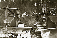
| Men and equipment of the 18th Engineers building a timber bridge across the Raspberry River north of Whitehorse, Yukon Territory. |
Responsibility for this mammoth undertaking went to gruff, 48-year-old Colonel (soon to be Brigadier General) William M. Hoge. Missouri-bred and West Point-educated, Hoge had won acclaim in combat during World War I. He went on to command a battalion charged with erecting roads and bridges in the Philippines’ jungle-covered Bataan Peninsula and later he ran a flood-control office in Nebraska. His superiors back in Washington, D.C., believed that if anyone could build a road from British Columbia to Alaska with the necessary speed and minimum trouble, it was Hoge.
Their faith seemed well placed. Even as Alaska’s governor Ernest Gruening — grandly irritated that the army should have ignored his recommendation of coastal Route A — blustered that the compromise plan ‘will not get us the highway in any reasonable period of time,’ American troops and civilians were already arriving for work in the far north by the spring of 1942. Coming by train and plane, they dropped into an area that boasted more caribou and moose than humans, and they arrived with what amounted to an armada of heavy equipment: 174 steam shovels, 374 blade graders, 904 tractors, and more than 5,000 trucks, as well as bulldozers, snowplows, cranes, and generators. Many Canadians were dubious about claims that the defense of Alaska meant the defense of Canada and they didn’t trust the United States to give up its control of the highway even after World War II ended. They were less awed than shocked by this rapid buildup in British Columbia and the Yukon. A headline from British Columbia’s Peace River Block News that spring revealed an uneasiness felt by many locals: ‘United States Troops Invade Dawson Creek to Build Alaska Road.’
No more comfortable, though, were the Americans assigned to road construction. One oft-repeated tale concerns a staff sergeant who, arriving in Dawson Creek during a blizzard, asked his superior officer, ‘Major, where do I sleep?’ The grinning major replied, as he put down his own bag, ‘Take any snowdrift you like. This one is mine!’
Living arrangements weren’t quite that harsh (there were at least tents and a mess hall for the road builders), but working conditions left much to be desired. After arriving at their destinations, troops cooled their heels for weeks, until spring thaws made it possible to begin construction, and more had to wait for their equipment to catch up with them. The cold and the exhausting pace of the work proved hard on the men, causing a few to pitch face-first into campfires as they warmed their hands above the flames. Lack of sleep took its toll in other ways. Wrecked vehicles became a common sight on the sides of the lengthening road. The supply of spare parts couldn’t keep up with the demand. According to Ken Rust, the 18th Engineer’s historian, the men worked ‘in coolie fashion, bending pick points in frozen ground and mucking around in rivers of mud, getting nowhere.’
Warmer weather only brought new hardships. Rivers flooded. Truck wheels were trapped in dense, grasping mud. Equipment became caught in forest fires. And Alaskan mosquitoes — ‘bush bombers,’ as the soldiers nicknamed them — proved far more troublesome to the men than the Japanese Zeros they’d been warned might breech the Pacific coastline at any moment. ‘You had to eat with your head net on,’ Hoge recalled, ‘you would raise the head net, and by the time you got food on the spoon up to your mouth it would be covered with mosquitoes.’
The land on which the new highway was being constructed stubbornly resisted taming. Most of it was covered for as far as the eye could see by dense spruce forest or boggy patches of vegetation called muskeg. The earth was so swampy in places that road builders could make progress only by laboriously felling trees and laying them down, side by side, to form a ‘corduroy road,’ a surface that would shift and buckle as the ground dried. Worse yet, the men had to build over permafrost (permanently frozen ground) that required corduroying, then dumping truckloads of earth and gravel on top of that to provide a usable road surface. Such problems slowed progress, especially in the road’s initial stages. Rust noted, ‘Swift moving Yukon streams resisted freezing and the underside of trucks that crossed them became ice coated . . . . After driving through water it was absolutely necessary to keep the vehicle moving, as ice would lock the wheels of a truck that stood still for a few seconds (not minutes, seconds), and any attempt to move forward would snap an axle.’ He added, ‘Trucks with bent frames and beds and distorted springs moved crabwise up the road. Some trucks broke in half, were left beside the road as derelicts. Men suffered but held up better than equipment.’
General Hoge soon realized that he would need additional troops to complete the road expeditiously. But with the Japanese stepping up their assaults in the South Pacific, most regular army engineers had been dispatched there. The War Department solved the problem by sending black units to Hoge’s aid. Commanders did not reach the decision easily. The army was still segregated in 1942, and officials were hesitant to post black soldiers in areas (especially the American South) where their presence might incite racial animosity. Furthermore, under the misapprehension that African Americans would be unable to withstand Arctic conditions, Secretary of War Henry L. Stimson had previously refused to post black troops in the far north. But the highway project’s need for manpower finally convinced Stimson to reverse his policy, and three black Engineer regiments — the 93rd, 95th, and 97th — were assigned to the project, boosting Hoge’s numbers by a third and increasing his command to 10,607 men.
In June 1942 the Japanese attacked Alaska’s Aleutian Islands, adding increased pressure to the fast pace of road building. Troops worked long hours in shifts, without a day off. Some companies used what they called a ‘train system’ of construction, with all units moving forward simultaneously — the heavy bulldozers in front, knocking down or uprooting trees, followed by other ‘dozers that pushed the debris to the sides of the road, and then work parties corduroying over soft spots, creating permanent bridges and culverts, and eventually giving consistent shape and borders to the roadway. In other places, companies of men labored in what can only be described as a leap-frog method: each crew took responsibility for a 5-to-10-mile stretch of road, and when a crew finished a section, it skipped to the front of the line and began work on another. As the summer of 1942 ended, Hoge’s reports to his superiors grew more optimistic.
The changes the road building brought to the region baffled the few isolated native and white trappers living there. ‘We were taking goods into the north by horse and dog sleighs the way our fathers and grandfathers had done,’ recalled one trader about his first encounter with the road builders, ‘when we met . . . a great fleet of trucks as far as the eye could see . . . . [T]ime went ahead more in a few minutes than it had in a whole lifetime. Like the snap of your fingers, we changed from the old to the new.’
In August 1942 Lieutenant General Brehon Somervell, the army’s chief logistician, made a four-day inspection of the highway to check on any problems and to see if any organizational changes were needed. He decided that the project was moving too slowly and that Hoge’s troops were ill prepared for the winter. The following month Somervell relieved Hoge of his command and replaced him with Brigadier General James O’Connor. Hoge later claimed that Somervell had fired him not because of Hoge’s shortcomings but to settle a score that dated from their service together in the 1930s.
An advance clearing crew of the 340th Engineers finally met the 35th Engineers on September 24, 1942, on a tributary of the Liard River — thereafter known as Contact Creek — to open the pioneer trail from Dawson Creek to Whitehorse. A month later the 18th and 97th Engineers encountered one another near Beaver Creek in the Yukon Territory. In just over six months soldiers and civilian contractors had laid down a supply road that many thought could never be built — certainly not so quickly. A statement from Secretary Stimson’s office praised the men who ‘pushed forward at the rate of eight miles a day, bridged 200 streams, laid a roadway 24 feet between ditches, [and] at the highest point, between Fort Nelson and Watson Lake, reached an altitude of 4,212 feet.’ But the exhaustive work caused one sergeant with poetic tendencies to write, ‘The Alaska Highway winding in and winding out fills my mind with serious doubt as to whether ‘the lout’ who planned this route was going to hell or coming out!’
At the highway’s official opening at Soldier’s Summit on November 20, 1942, General O’Connor speculated that the building of this road might someday ‘become an American saga ranking with the epics of Frmont and Lewis and Clark.’ Yet the story wasn’t over. As late as the close of 1943 some 11,000 military men were still assigned to the region, under the direction of the PRA, and progress on the road continued until well after the war, as workers replaced temporary bridges with steel spans and relocated some sections to improve the army’s two-lane track.
Questions about the highway’s usefulness persisted as well. As late as 1947 Congressman Warren Magnuson of Washington continued to promote construction of Route A, which he called ‘the real Alaska Highway.’ The road also figured in a 1943 U.S. Senate investigation of the CANOL Project led by Harry Truman, the junior senator from Missouri. Truman’s committee determined that the pipeline had been raised in haste, at extraordinary taxpayer expense, and that it failed to provide a local source of oil that would be necessary in the defense of Alaska.
Thanks to that probe and others like it, Truman earned national renown and the nod to become Roosevelt’s last vice president. After the war, Truman saw the U.S. government sell off or dismantle CANOL’s components. But the highway persisted. It opened to tourist traffic in 1948, and over the following decades, Alaska and British Columbia refined their respective sections. Now completely paved, the road offers an extraordinary (and often extraordinarily lonely) journey into the northern wilds. Built to speed supplies north, it is now a road over which to linger and enjoy one of the twentieth century’s great engineering marvels.
This article was written by J. Kingston Pierce and originally published in the January 2001 issue of American History Magazine. For more great articles, subscribe to American History magazine today!