
The Sept. 13, 1759, clash between British and French soldiers on the Plains of Abraham, before the very walls of Quebec City, was a relatively minor affair, yet it was one of history’s most decisive battles. Fewer than 8,000 troops were engaged, but had the outcome gone the other way, the political map of North America probably would look much different today. For almost 150 years Great Britain and France had jockeyed with one another to expand their holdings in North America. By the middle of the 18th century Britain controlled most of the continent along the Atlantic coast east of the Appalachians and south of the St. Lawrence River. Encompassing great swaths of territory west of the Appalachians was the province of New France, organized into a handful of colonies, bookended by Louisiana in the south and Canada up north.
The Seven Years’ War (1756–63), waged in North America as the French and Indian War, brought an end to French colonial ambitions on the continent. Fighting there actually began in 1754. On July 25, 1758, the British scored a major strategic victory when they seized the fortress of Louisbourg on Cape Breton in northeastern Nova Scotia, thus exposing Canada to invasion via the St. Lawrence River. By June 1759 the British had penetrated more than 400 miles upriver, establishing a base on Île d’Orléans, a few miles downriver from Quebec. Perched atop bluffs on the north bank of the river, the fortified capital of New France was difficult to attack directly from the river. But by fall the British controlled the entire south bank far upstream of the city, and on September 13 a British assault force under 32-year old Maj. Gen. James Wolfe drifted downriver from St. Nicholas and landed before dawn in the isolated cove at Anse-au-Faulon, just west of the city. An ad hoc battalion of light infantry had already scaled the cliffs and taken control of the road to Quebec, allowing the three brigades of Wolfe’s main force to march undetected up the steep and narrow road from the river to the top of the bluffs. The Redcoats then formed up on the Plains of Abraham, a large open field within sight of the city walls.
When French Lt. Gen. Louis-Joseph de Montcalm-Gozon learned of Wolfe’s landing, his main force was near Beauport, about 5 miles east of the city. Having assumed the British would try to force a landing there, the French commander realized he’d been outmaneuvered. As local militiamen skirmished with Wolfe’s troops to buy time, Montcalm fast marched his regular forces from Beauport, finally deploying them along the Buttes-à-Neveu, a low ridge directly in front of Quebec’s landward outer walls. Seeking to dislodge the British before they could dig in, Montcalm—mounted conspicuously on a dark charger—led his troops to the attack at about 10 a.m.
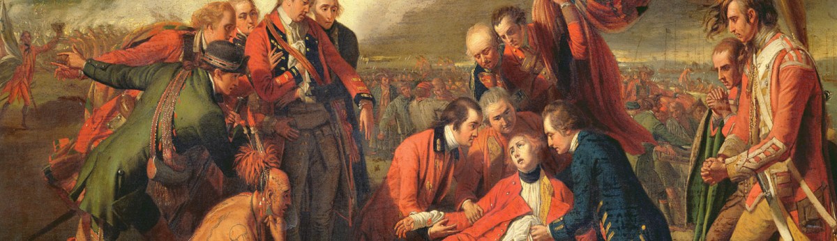
Wolfe had ordered his men to load their muskets with double balls and hold their fire until the French advanced to within 30 yards. When the Redcoats did fire, Montcalm’s battle line disintegrated, sending the surviving French troops racing back toward Quebec. Both Wolfe and Montcalm were mortally wounded in the exchange, and Wolfe’s second-in-command, Brig. Gen. Robert Monckton, was seriously wounded. After a period of confusion, Brig. Gen. George Townsend took command of the British force, and Quebec’s defenders ultimately surrendered to him on September 18.
But the French weren’t ready to give up the city. As winter set in, pack ice forced the Royal Navy to leave the St. Lawrence. When the spring thaw came, the regrouped French besieged the depleted British garrison at Quebec from the landward side. On April 28, 1760, the armies fought another battle on the Plains of Abraham [see “A Fool’s Errand,” by Michael G. Laramie, January 2016], this time with their positions reversed. While the British lost the day, they outlasted the subsequent siege. Within two weeks a Royal Navy fleet arrived, and the French withdrew. At war’s end in 1763 France was forced to cede to Britain both Canada and the eastern half of Louisiana, from the Appalachians to the Mississippi River. A year earlier by secret agreement France had transferred Louisiana to Spain, but in 1800 Spain, under duress, transferred western Louisiana territory back to France. Three years later Napoléon Bonaparte sold it to the United States for $15 million.
Over the next century development claimed much of the Plains of Abraham. In 1908 officials designated a section of it as a national battlefield park [ccbn-nbc.gc.ca/en]. Today the park encompasses 240 acres along the bluffs overlooking the St. Lawrence. A monument raised in 1790 marks the spot where Wolfe was said to have fallen. While a modern shipping terminal occupies his landing place on the river, the cliffs his infantrymen scaled appear largely as they did in 1759.