At a remote geographical site in southeast Colorado called ‘the Wall,’ some of the pictographs decorating the south side were created by cattle drovers, not Indians.
In the American West, many examples can be found of ancient carvings in rocks (petroglyphs) and ancient paintings on rocks (pictographs). It is believed that most of these intriguing figures were made by early, cliff-dwelling Indians. It’s rare to see such art created in the late 19th century by American cowboys. Primitive cowboy rock art, however, dominates one stony location in southeastern Colorado.
The cowboys driving vast herds up the great Chisholm Trail in the mid-1880s didn’t know they were seeing the end of an era, nor could they understand the complex forces at work. The end of the drives north from Texas to Kansas resulted from several factors, chief of which was bovine piroplasmosis, a disease known 100 years ago as “Texas Fever.” Spread by ticks, the fever killed local cattle whenever Texas Longhorns arrived. Another factor dooming the Chisholm Trail was that as progressive ranchers improved their stock with imported breeds, restrictions against the Longhorns were imposed.
It was about this time that new cattlemen began to need a better trail. The Eddy brothers—Charles Bishop and James Arthur Eddy—were developing an enormous cattle ranch in southeastern New Mexico Territory. Branding VVN, the Eddys intended their cattle for a mostly unexploited market—the mining districts of central Colorado. It was nearly impossible to drive cattle from Colorado’s plains over the Front Range to the silver camps, but herds driven from the south along the Arkansas River into South Park could summer on the rich mountain grasses and be sold at high prices. At first, the Eddys followed the Goodnight-Loving Trail from today’s Carlsbad, N.M., to Raton, N.M., and through Raton Pass, but their trail bosses didn’t carry a lot of cash, and the exorbitant tolls charged at the pass drained their resources.
Raton Pass was one of the most famous elements of the Santa Fe Trail. A steep but accessible break between the soaring mesas of the Front Range, it offered good water and an easy climb for herds, but it had poor grazing due to the many thousands of oxen and mules that teamsters had driven through over the years. The new Atchison & Santa Fe Railway right of way also constricted passage. Finally, “Uncle” Dick Wooten’s ranch blocked the way, assessing tolls (see “Pioneers and Settlers” in the February 2007 Wild West).
The needs of cattlemen, however, were different from teamsters. They didn’t necessarily need a beat-in-the-dirt road that crawled over the mountains. They did need water, grass and good crossings for their herds. For this reason, they could drive through rougher terrain as long as it didn’t “bust up” a herd with obstacles.
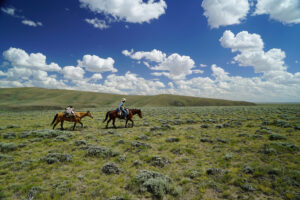
To this end, cattlemen had scouted for a more easterly route. Before long, they selected a passable route branching off from the Goodnight Trail. Called the “Eddy Diversion” in later years, the new route passed near today’s Folsom in northeastern New Mexico. The country there was partly covered in pine, and though broken up with small canyons and streams, it had good grazing. From the Folsom area, the diversion passed through Trinchera Pass on the New Mexico–Colorado border, then headed northwest to a crossing of the “Picketwire,” the Purgatoire River, near today’s Highway 160 in southern Colorado. From there, the trail crossed today’s Comanche National Grassland to the Arkansas River. It’s unknown how many cattle were driven up this trail, but perhaps as many as 10 or 12 herds a year—each numbering 1,500 to 2,500 cattle—went through Trinchera Pass in the years 1884-1904.
An odd geological feature called “the Wall” appeared as the trail broke into more open country at the mouth of Trinchera Pass. A relic of a basaltic dike, the Wall is composed of angular basaltic columns laid on their sides, as if stacked to make a wall. In places, the Wall is at least 15 feet high and 10 feet wide. Some sections are overgrown with juniper and scrub. The north side of the Wall is covered with verdant lichen, some sage gray, some bilious green. At one spot, some anonymous herder carved a wind shelter into the rock, using the blocks he had carved out to form a corral in front of the shelter. In case the wind changed, this thoughtful herder also built a cedar and galvanized iron shelter on the opposite side of the Wall.
It is on the south side of the Wall, however, that the region’s greatest treasure was created. Long-ago Indians had used the dark basalt to make pictographs of animals, insects and symbols. Perhaps 200 Indian pictographs remain, most quite clear to this day. Seeing these, the drovers, cowboys and wranglers were inspired. In a short period of perhaps just 20 years, they left a pictorial legacy of cowboy life unequaled anywhere.
They were not artists, they were cowboys. Their drawings are little more than stick figures, but they reveal a charming sense of humor and an eloquent grasp of history. The cowboys themselves knew what made them memorable. Prominent in their drawings are high-heeled boots, 10-gallon hats and six-shooters. One cowboy, in recognition of the Indian artists who had preceded him, represented himself shooting a bow and arrow. Another overlooks a trail and waves hello to a rare visitor. A Mexican cowboy left a romantic inscription about his wife. Others scratched crosses. Several cowboys ride forever on horses, and one slaps his mount with a quirt.
In addition to these pictures, the cowboys left their initials and brands. Though the author half-expected to find the Eddy brothers’ VVN brand somewhere, he did not. The most famous brand found was the JAL brand of the Cowden brothers of Monument Draw, Texas and New Mexico Territory, though there is also a mark suspiciously like the famous “Running W” of the King Ranch of south Texas. Did the Eddys’ trail boss, Martin Mrose, leave his initials? There is an “MM” written on one stone, but it’s hard to say if it’s his.
Oddly, in areas where brush has overgrown the Wall, there are no pictographs or marks, which indicates the brush has grown in these particular places for a very long time. A mysterious cairn a short distance from the Wall looks suspiciously like a grave.
There is a proposal to turn more of southeastern Colorado into a military preserve. The Wall, which is a mile or so north of the New Mexico–Colorado state line, doesn’t seem to be involved. It is far off the beaten path, on private land, and hopefully will remain protected by its own noble isolation. The cowboy rock art of Trinchera Pass is among the great treasures of the West and must be protected. Only plain etchings by common cowboys, these unpretentious marks are filled with spontaneous joy, humor and beauty. Long live the simple American cowboys who made them!
Author Dennis McCown is a college instructor in Austin, Texas, and a part-time cowpoke on his father-in-law’s ranch.
Originally published in the April 2008 issue of Wild West. To subscribe, click here.