Gettysburg’s famed Electric Map reopens in Hanover, PA, ready for a new generation of Civil War enthusiasts.
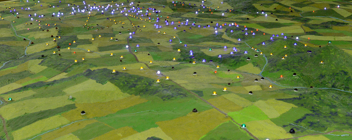
Scott Roland and Marc Charisse are bent over a network of wires, making connections, testing things out and adjusting their computer records. Sprawled before them is a green expanse about the size of half a tennis court. Instead of being flat, however, it is uneven, with discernible ridges and sharp bumps, and punctuated by a patchwork of colors. This is the beloved Gettysburg Electric Map, a ghost of the battlefield being brought back to life in Hanover, Pa.
As the men tinkered with the wiring, the map’s June reopening to the public was only a few days away. “Hold on,” Roland said, then turned off the bright overhead lighting. At that point, with a flip of a switch, dozens of small lights came on across the map, creating their own firmament in the darkened room. Although the Electric Map has been upgraded and the whole display is now tied to a sophisticated new system, the exhibit still retains its wholesome, low-tech charm. Turned on and off in succession, these points of light help tell the story of the Battle of Gettysburg, pinpointing important landmarks and showing the movement of troops during three crucial days in July 1863.
But the map’s reopening, like the outcome of the battle itself, was by no means assured at the project’s outset.

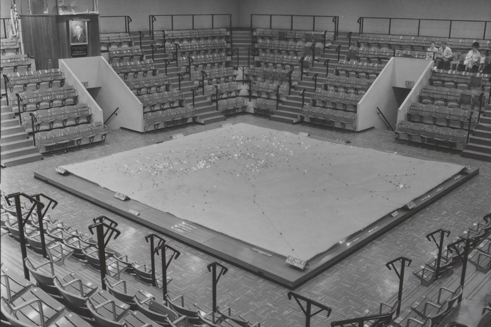
Created in 1962 to coincide with the battle’s centennial, the electric map once formed the centerpiece of the old visitor center at Gettysburg National Military Park, which was located on the Taneytown Road across from the Gettysburg National Cemetery (the site of Lincoln’s famous speech in November 1863). Old National Park Service brochures touted visiting the Electric Map as an essential first step in understanding the battlefield. The NPS had acquired the 29-by-29-foot map from private owners when the old visitor center opened in 1972. Constructed from steel I-beams, a wood and plywood platform, plaster molding and paint, the map employed more than 600 miniature light bulbs and weighed 12 tons. A 22-minute audio program narrated the history of the battle for park visitors, who viewed the presentation from above, in a 554-person stadium-seating theater from the early 1970s until April 2008.
The Electric Map was once regarded as a technological and interpretive marvel. Updating an earlier version of an electrified map that he had created decades before, local historian Joseph L. Rosensteel painstakingly created a new version for the battle centennial, molding and painting it to demarcate farms, roads and railroad lines, and turning the Pennsylvania countryside into a bucolic, multicolored quilt. According to a history published in The Baltimore Sun, the Rosensteel family were longtime artifact collectors and history buffs, and for many years it was Rosensteel’s own voice heard on the narration (the NPS rerecorded it in the 1980s). Family legend has it that Rosensteel’s children could all recite his narrative by heart, and one son even gave dramatic presentations of it at the dinner table. The elder Rosensteel died in 1964, only a year after his map opened.
The narration begins by orienting visitors and explaining the relative location of the town of Gettysburg. In many ways, it is a relic of its time, leaving out more minor characters and nuanced stories that might be included in a battle description today. The narrative is strictly a military history, told in broad strokes. As the lights show the Union and Confederate armies converging across the battlefield, the narrator points out famous landmarks such as the Peach Orchard and Devil’s Den—even the locations of campfires as night fell. The Day 2 narration highlights the leadership of Union Brig. Gen. Gouverneur K. Warren in defending Little Round Top. Joshua L. Chamberlain’s valiant defense of the rocky hill, made famous in the 1974 book The Killer Angels, is not mentioned. Day 3 focuses on what the narrator calls “one of the greatest infantry charges in history,” when the advancing “butternut” troops faced “a roaring volcano” on Cemetery Ridge. “Brothers fighting brothers, each for the cause he thought was right,” the narrator intoned. “Fifty minutes—50 minutes—and the greatest infantry charge in our history…was history.”
For millions of visitors, it was the rolling plaster topography of the map, the sequencing of the lights, and the sonorous narration that first enabled them to understand the significance of the battle and its major players: Lee, Longstreet, Meade and Warren. It undoubtedly helped to orient them when they went out and toured those landmarks on the sprawling battlefield—places like Little Round Top, Devil’s Den and Seminary Ridge—for themselves.
Yet as time went on, the map increasingly generated headaches for the Park Service. The plaster cracked and showed its age, and it contained crumbling asbestos, a health hazard. Audience expectations changed. The blinking lights that had drawn oohs and aahs from one generation of children seemed to pale in comparison to the personal computers and handheld devices favored by the next one. The conventional wisdom was that visitors now expect more interactivity from their museums. Stadium seating was too distant; the map too static. “From an architectural standpoint, it takes up an immense amount of space,” former Superintendent John Latschar told The Baltimore Sun in 2008. “And we have consistent problems with school kids falling asleep.”
When the NPS was planning its new visitor center and Cyclorama complex located on the Baltimore Pike, a process that included demolishing the old visitor center and Richard Neutra–designed Cyclorama building, the Electric Map became a casualty too. In its place, the NPS installed the Cope Map, a 10-by-10-foot topographic map of the battlefield created in 1904 by military engineer Emmor B. Cope, in the new visitor center. The Electric Map was shut down, unplugged, cut into four pieces and put into long-term storage, its future decidedly uncertain.
Although the old exhibit was gone, it was far from forgotten. On the review site TripAdvisor, someone recorded sentiments that have been echoed by others. “I first visited Gettysburg in the 1970s and the best single tool for understanding what happened was the electric map that used electric lights to show the movement of troops over the three days of the battle,” wrote that visitor. “Now the old visitor center and map are gone. The new visitor center is fancier and bigger, but the electric map is in storage somewhere (I was told). That was a HUGE disappointment. Bigger is not always better. Bring back the map!”
Private citizens formed a “Save the Electric Map!” website, advocating that the map be reinstalled or reused in some fashion. In 2012 Roland, a Pennsylvania developer and businessman, took the first major step toward that outcome by purchasing the map at auction for just over $14,000. His intention was to move the display to Hanover, 14 miles east of Gettysburg, with the goal of increasing heritage tourism to the town and linking it more solidly to the Gettysburg story. Hanover was the site of a cavalry clash just prior to the Battle of Gettysburg when, on June 30, 1863, Confederate troopers under J.E.B. Stuart were met by Union Generals Judson Kilpatrick’s and George Custer’s men.
Today the dream of preserving and reopening the Electric Map has been realized. The exhibit has been reassembled, rewired (including an estimated total of 7½ miles of wiring), relit (with LED bulbs), and replastered and repainted (where needed) in the Hanover Heritage and Conference Center at 22 Carlisle Street, right in Hanover’s downtown. Visitors can get much closer to the map than before and also walk around it as they listen to the original narration.
Charisse, the center’s director and an adjunct professor at York College of Pennsylvania, also hosts walking tours focusing on Hanover’s wartime heritage and is planning future exhibits in the center (now open only on Thursdays, Fridays and Saturdays). He admits that the map isn’t completely accurate geographically; the Big and Little Round Tops seem a bit out of scale, among other quibbles. (He points out that the map used to be viewed from above rather than ground level, after all.) But overall, he contends, the map still offers a valuable history lesson. “This is an icon to people,” he says. “Nowhere else can you get, in one quick look, this kind of overview. This is the big picture of Gettysburg. Then people can go out on the battlefield to learn more of the details.”
People can also learn how a casualty of the battlefield—not a soldier, not a monument, but a beloved and historic map—was saved so that an old story could be told to new generations, who still long to hear it.
Kim O’Connell, based in Arlington, Va., saw the Electric Map in the old visitor center during her first trip to Gettysburg, nearly 25 years ago. She has written about the Civil War for The New York Times, National Parks, National Geographic News, Preservation and other publications. Natasha Magallon is a writing student at the New School in New York City.